Help
Help
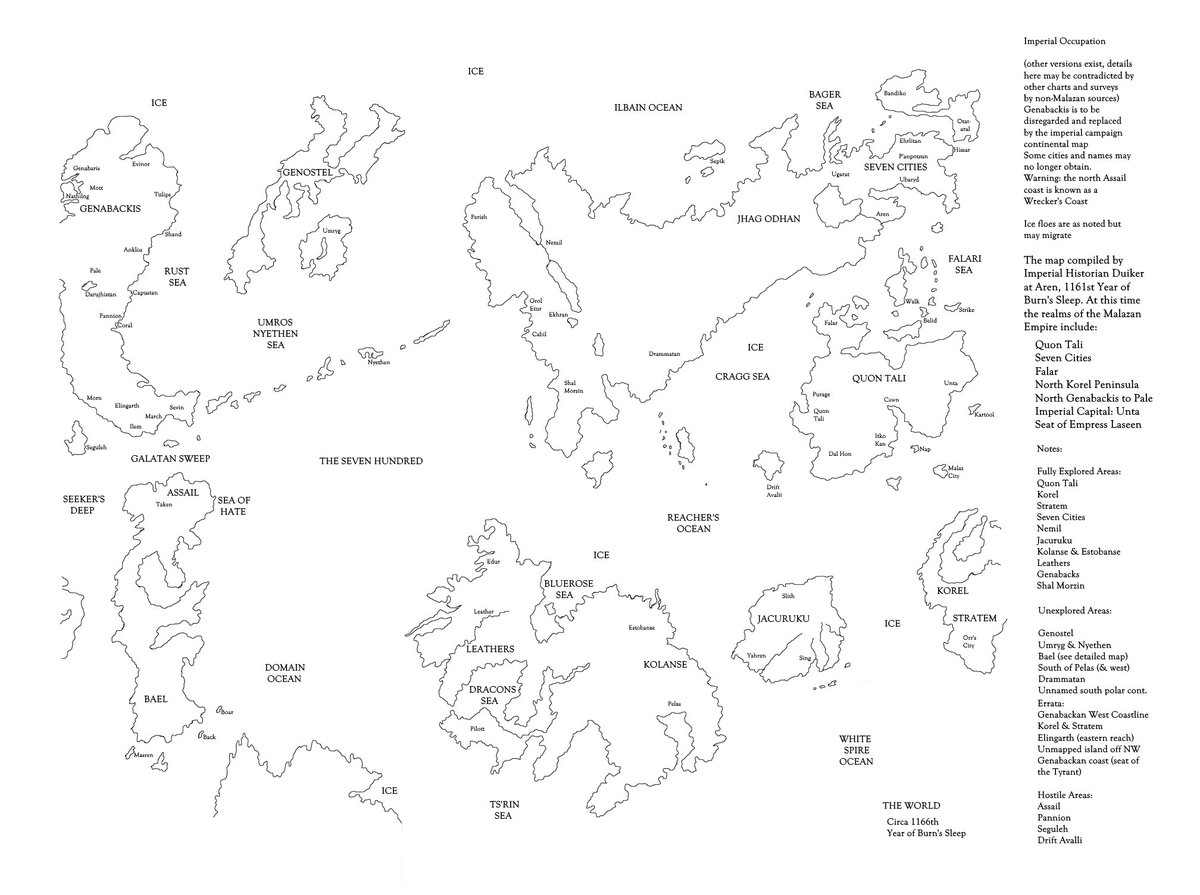
 Malazan Hand-Drawn by Erikson.jpg (125.07K)
Number of downloads: 30
All the basics, if hard to read. Still pretty cool. My own work started out with a map just like this.
 Tatterdemalion
Posted 15 August 2018 - 04:17 AM
Malazan Hand-Drawn by Erikson.jpg (125.07K)
Tsundoku

Posted 15 August 2018 - 07:20 AM
Puck

Posted 15 August 2018 - 12:25 PM
End of Disc One
Posted 15 August 2018 - 02:48 PM
Tatterdemalion
Posted 15 August 2018 - 04:37 PM
Gorefest
Posted 15 August 2018 - 07:19 PM
 End of Disc One, on 15 August 2018 - 02:48 PM, said:
This post has been edited by Gorefest: 15 August 2018 - 07:20 PM
worry

Posted 15 August 2018 - 07:48 PM
End of Disc One, on 15 August 2018 - 02:48 PM, said:
D'rek

Posted 15 August 2018 - 08:58 PM
worrywort, on 14 September 2012 - 08:07 PM, said:
Werthead

Posted 15 August 2018 - 09:53 PM
Puck
Posted 16 August 2018 - 11:23 AM
Luv2B_Sassy, on 15 August 2018 - 07:48 PM, said:
End of Disc One, on 15 August 2018 - 02:48 PM, said:
This post has been edited by Puck: 16 August 2018 - 11:24 AM
Werthead
Posted 16 August 2018 - 08:58 PM
This post has been edited by Werthead: 16 August 2018 - 10:57 PM
Werthead
Posted 16 August 2018 - 10:03 PM
Werthead
Posted 16 August 2018 - 10:36 PM
 Tatterdemalion
Posted 17 August 2018 - 04:01 AM
nacht

Posted 17 August 2018 - 04:04 AM
Tatterdemalion, on 17 August 2018 - 04:01 AM, said: