The Bonehunters is in my possession! (performs dance of victory)
Korelri is reported as being still recovering from the CG's fall and contains a northern subcontinent surrounded by numerous islands. From this I'm guessing that the northern landmass is 'Korel' and the southern is 'Stratem' and together they form 'Korelri', so they are two seperate landmasses (although how this relates to Stratem "being beyond Korelri's southern range" is unclear).
We have the names of two more oceans as well, which is good. Not too sure about how there's an ice sheet in the north-west of Quon Tali in what must be approaching the equatorial region, but I'm guessing magical reasons for that.
Genabackis being in the north seems to be necessary due to the distance of 3,000 leagues being given for the Unta-Pale distance, the 1,600 league-distance being given for Seven Cities-Genabackis and the fact that Crokus and co. left Genabackis' central-west coast, sailed south-west for two months and then landed on Otataral's north-east coast. The Malazans being in the north could be a result of the currents. However I have moved Genabackis a bit further south to compensate. Lether I've moved north a bit as well with a bit of fiddling to get Jacuruku and Assail into better locations.
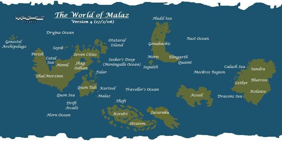
@ Gothos, no Jacuruku's surface layers (the dust and ash from the destroyed kingdom) was used to create the Imperial Warren, leaving the continent "bare to heal". In Memories of Ice one of the Imass clans is also said to be on Jacuruku in the present day, meaning it still exists. Korelri is an open question. It may be the difficulties with the front are due to the number of islands in the area and the Korelri people may have fleets that can land reinforcements behind Greymane's lines and so forth. But it's possible that Korelri can be much larger than I've made it, especially if it connects with the southern polar ice cap.
 Help
Help
 . Thank you.