Malazan Empire: Malazan World Map - Malazan Empire

Jump to content

  • 11 Pages +
  • « First
  • 8
  • 9
  • 10
  • 11
  • You cannot start a new topic
  • You cannot reply to this topic

Malazan World Map Unofficial map of the world. Rate Topic: -----

#181 User is offline   D'rek 

  • Consort of High House Mafia
  • Group: Super Moderators
  • Posts: 14,599
  • Joined: 08-August 07
  • Location::

Posted 14 February 2011 - 11:14 PM

That's lots of reading up there, so here's my justification for an eastern Jacuruku in semi-pictographical form. Not saying that this proves Jacuruku is on the east, just that if it is this is how all the quotes are justified:

Attached File  
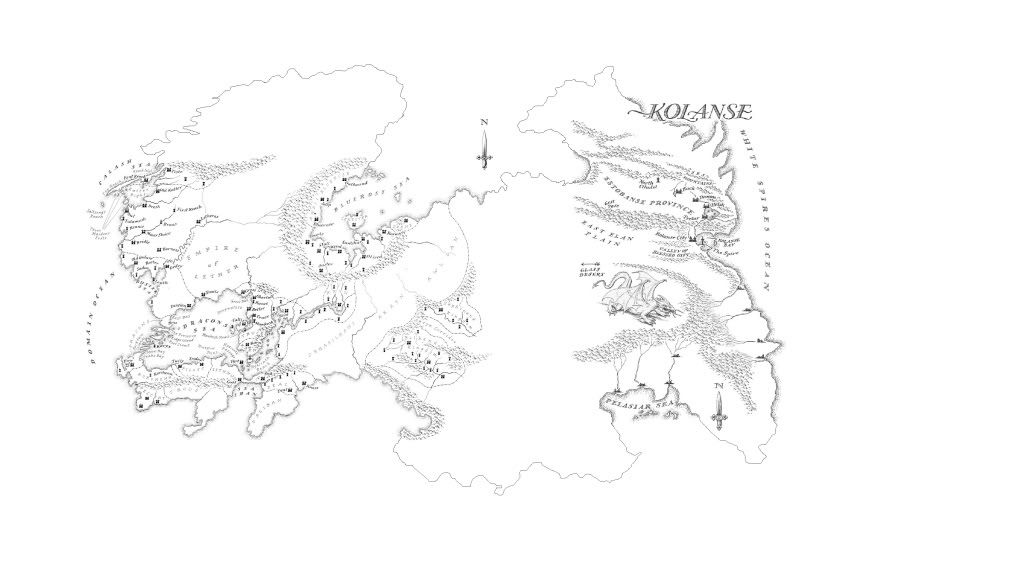
Map of Korel-Stratem and Jacuruku with paths.jpg (272.42K)
Number of downloads: 53

Bars' Journey

Per RG, Bars' blade is dropped off on the east coast of Jacuruku by Shurq and make their way across the continent. Avoiding Jhest's mageocracy, they turn a bit north where people less likely to kill them and more likely to have a boat may be found (as noted by Kyle's group at the Dolmens). They find a ship and set out, but are soon wrecked in a storm [1]. They drift in a broken raft for a bit, before being picked up by Hestral's ship [2]. Bars kills Hestral, takes command of the ship [pink group] and orders it south-west, around the cape [10] to Stratem. Around [3] a few different things could happen - we know at some point they're lost in mists and run into Oru, but it's unclear where. Maybe they never make it to Stratem, maybe they get there and turn around because the Crimson Guard have already shipped out to Quon. Either way, the ship ends up on the edge of the Sea of Storms and destroyed by a Mare galley.

Kyle's Journey

So Kyle and the Lost Brothers [green group] with the CrimGuard heading north-west from Bael to Stratem [4]. The lead ship(s?) get to Stratem first thanks to some strange Stormrider intervention and go into the inner sea to the Guard's old tower [5]. There Kyle sees Stoop get killed and runs west, with the Lost brothers joining him. They run into some tribals who teleport them with Serc [6 to 7]. At the west coast they join with Ereko and Traveller [purple group], initially heading north to get out of a little cove, then south around Stratem. At the south end of Stratem they are close to some Jaghut manifestation even further south, with its enormous glacier and icebergs (we never hear of icebergs elsewhere, hence why I prefer the southern route to them going north of Korel). They break from Stratem and go north-east to Jacuruku, eventually spotting a part of its southern coast [9]. They go north-west along its coast, following the shoreline of desert and jungle beyond. They eventually land to meet Jhest [10], where Kyle notes the sun rising to the east over the jungle. They continue skirting the north coast, eventually reaching the Dolmens of Tien [11]. Ereko dies, Jan joins them [gold group], they head north, then north-west. A big storm is ahead, so they change course a few times [12, 13, 14], but can't avoid it and randomly set themselves north-east (better currents in that direction, perhaps?) before plunging into the storm.

View Postworrywort, on 14 September 2012 - 08:07 PM, said:

I kinda love it when D'rek unleashes her nerd wrath, as I knew she would here. Sorry innocent bystanders, but someone's gotta be the kindling.
2

#182 User is offline   Sinisdar Toste 

  • Dead Serious
  • View gallery
  • Group: Malaz Regular
  • Posts: 3,851
  • Joined: 14-July 07
  • Location:The C-Hood

Posted 15 February 2011 - 07:06 AM

heh, i agreed with your last comment about stratem d'rek, and since then i've done almost the same thing with it.

regarding jacuruku's placement, i was actually mistaken about the moi prologue. k'rul crosses korel, then comes to the shore of jacuruku and tells draconus he is on the west shore. so if d'reks reasoning is to be believed, jac is east of korel

Attached File(s)


There's a fine line between genius and insanity. I have erased this line.

- Oscar Levant
0

#183 User is offline   snake0026 

  • Sergeant
  • Group: Malaz Regular
  • Posts: 63
  • Joined: 03-March 08
  • Location:Downtown Toronto

Posted 15 February 2011 - 08:34 PM

Wow, that was quite a compelling case. Jacurkuku to the east it is.

View PostD, on 14 February 2011 - 09:33 PM, said:

[Really? So if you were in Europe and didn't want to go to Australia (but knew that the Australian danger was contained to that continent anyways), you'd be afraid to go anywhere in Asia? :(


And you should never, EVER, underestimate the Great Australian Danger. One can never be too many continents away from that hell-hole, what with their Killer Koalas, baby-stealing dingoes, Kangaroos that go by the name, "Jack," and, perhaps most terrifying of all, vegemite. :(
"But I saw you [Snake]…faced by Anomander [Mandy] himself. How did…"
"I escape? Well, I dazzled him with fancy words, edging ever closer, then used my ninja skills to strike like a cobra, knocking the sword [Spamnipur] away and drop-kicking him over the side before tumbling backwards, slaying another Piss'd Andii on the way."
Silence. Lots of silence. "Fine!" He shrugged and grinned, "Someone hit him in the face with a coin, and he cursed just long enough for me to get away." ~ Excerpt from Gardens of the Tea Spoon
1

#184 User is offline   Werthead 

  • Ascendant
  • Group: Malaz Regular
  • Posts: 3,540
  • Joined: 14-November 05

Posted 21 February 2011 - 04:43 PM

New information from TCG's map of Kolanse:

The Bluerose Sea appears to be landlocked, or if it opens to the outside ocean it's a narrow channel in the north: RG/DoD show the sea's south-western end, TCG the eastern. How much space is between the two is unclear, since the Glass Desert doesn't appear on either and is supposed to be pretty big, so there is scope for the Bluerose Sea to open to the exterior ocean in the north somewhere.

The White Spires Ocean lies to the east of Kolanse. That's the same ocean that washes against Stratem's south-western shore in RotCG, apparently canonising the idea that Lether and Korel/Stratem are somewhat close together (to within a few thousand miles anyway). What this means for Jacuruku is unclear: either Jacuruku is very small and located north-east of Lether and north-west of Korel (which is problematic as Quon Tali gets in the way) or Jacuruku is indeed to the east of Korel, as prior evidence suggested.

The STONEWIELDER map is on display in the appropriat book forum and shows how close Malaz and Korel are, much closer than most of the maps have shown so far.
Visit The Wertzone for reviews of SF&F books, DVDs and computer games!


"Try standing out in a winter storm all night and see how tough you are. Start with that. Then go into a bar and pick a fight and see how tough you are. And then go home and break crockery over your head. Start with those three and you'll be good to go."
- Bruce Campbell on how to be as cool as he is
0

#185 User is offline   D'rek 

  • Consort of High House Mafia
  • Group: Super Moderators
  • Posts: 14,599
  • Joined: 08-August 07
  • Location::

Posted 21 February 2011 - 05:20 PM

View PostWerthead, on 21 February 2011 - 04:43 PM, said:

The STONEWIELDER map is on display in the appropriat book forum and shows how close Malaz and Korel are, much closer than most of the maps have shown so far.


But the Malaz Isle on that map is "fabled", so should we really be considering it's location on the map as absolute truth?

View Postworrywort, on 14 September 2012 - 08:07 PM, said:

I kinda love it when D'rek unleashes her nerd wrath, as I knew she would here. Sorry innocent bystanders, but someone's gotta be the kindling.
0

#186 User is offline   Werthead 

  • Ascendant
  • Group: Malaz Regular
  • Posts: 3,540
  • Joined: 14-November 05

Posted 21 February 2011 - 07:26 PM

View PostD, on 21 February 2011 - 05:20 PM, said:

View PostWerthead, on 21 February 2011 - 04:43 PM, said:

The STONEWIELDER map is on display in the appropriat book forum and shows how close Malaz and Korel are, much closer than most of the maps have shown so far.


But the Malaz Isle on that map is "fabled", so should we really be considering it's location on the map as absolute truth?


I'd go with it in lieu of better maps. The water between Malaz and Korel is also called a 'strait' many times, so a few dozen or hundred miles wide at the most whilst the maps in this thread suggest a vaster distance. We can always reassess if more info is revealed in ICE's books.
Visit The Wertzone for reviews of SF&F books, DVDs and computer games!


"Try standing out in a winter storm all night and see how tough you are. Start with that. Then go into a bar and pick a fight and see how tough you are. And then go home and break crockery over your head. Start with those three and you'll be good to go."
- Bruce Campbell on how to be as cool as he is
0

#187 User is offline   Seregahl 

  • Recruit
  • Group: Malaz Regular
  • Posts: 1
  • Joined: 19-November 10

Posted 23 February 2011 - 11:49 AM

Hiho,
I took the map of sadist and also some informations of the other comments and worked a little bit with them.
First I hve to say, that the continent of Lether in my opinion have to be a little bit closer to Korel and also mor in the south. Then it makes sense that in Leteras there is a very hot subtropic climate. Then also the distance the 14th armee sailed to Lether would not be more than 3000 leagues... But I think the direction is right. Two reasons: The Vereder (I d'ont know if it's the right name in english, I only know the german names) are landing on the eascost and serch allys and Tavore saild around the continet to find a way strait to Letheras, and she found one: The river Lether.
@ D'rek:
I think your opinion of the new form of the continent Korel is right, but I haven't enough time to already change my map. :-) But it's not finishd and I will change it again ^^

@ all:
If you have new informations where on my map I have to change something, let me know it and I will do my best to create a right map of the Malazan World.

At the end: Im sorry for the mistakes I made, but english is not my mother tongue ;-)

Attached File  malazmap roxio 2.jpg (1.99MB)
Number of downloads: 19
file:///C:/Users/STEFAN%7E1/AppData/Local/Temp/moz-screenshot.pngfile:///C:/Users/STEFAN%7E1/AppData/Local/Temp/moz-screenshot-1.png

This post has been edited by Seregahl: 08 August 2011 - 08:03 PM

0

#188 User is offline   Gothos 

  • Map painting expert
  • Group: Malaz Regular
  • Posts: 5,428
  • Joined: 01-January 03
  • Location:.pl

Posted 26 February 2011 - 11:31 AM

Guys, how about a scan of the Kolanse map? Too long till my copy will reach my hands (weeks!)
It is not the critic who counts; not the man who points out how the strong man stumbles, or where the doer of deeds could have done them better. The credit belongs to the man who is actually in the arena, whose face is marred by dust and sweat and blood, who strives valiantly; who errs and comes short again and again; because there is not effort without error and shortcomings; but who does actually strive to do the deed; who knows the great enthusiasm, the great devotion, who spends himself in a worthy cause, who at the best knows in the end the triumph of high achievement and who at the worst, if he fails, at least he fails while daring greatly. So that his place shall never be with those cold and timid souls who know neither victory nor defeat.
0

#189 User is offline   Werthead 

  • Ascendant
  • Group: Malaz Regular
  • Posts: 3,540
  • Joined: 14-November 05

Posted 26 February 2011 - 05:42 PM

Badly-lit version.

Overlit version.

Obviously let me know to remove these if this isn't okay, but posting the maps from previous books seems to have been all right in the past.

As to how this fits with the Lether map from RG/DoD, the version Seregahl and Sadist developed above seems to be about the right size. There is a bit of uncharted land between the two maps, enough to fit the Wastelands, the West and Central Elan Plain and the Glass Desert in (going by the MT scale, Lether is a pretty huge continent though and the scale is large, so these don't need to be gargantuam on the map, maybe just a bit bigger tha say the Awl'dan plain), as well as the rest of the Bluerose Sea (I'm assuming the body of water in the north-west is the far eastern shore of the Bluerose, but this may not be the case; in fact, if it is there is a question why the Bonehunters couldn't comandeer a Letherii fleet and sail all the way to Kolanse rather than braving the Wastelands).

In the south, the Pelasiar Sea appears to be a nearly-enclosed bay, but not completely landlocked, as there is talk in DoD of Letherii sailing there and back. So a headland dipping down to the east of the Pelasiar (with the Otepelas Isles in the middle somewhere) before swining back up along the coast of the White Spires Ocean (which separates Lether from Stratem).
Visit The Wertzone for reviews of SF&F books, DVDs and computer games!


"Try standing out in a winter storm all night and see how tough you are. Start with that. Then go into a bar and pick a fight and see how tough you are. And then go home and break crockery over your head. Start with those three and you'll be good to go."
- Bruce Campbell on how to be as cool as he is
0

#190 User is offline   D'rek 

  • Consort of High House Mafia
  • Group: Super Moderators
  • Posts: 14,599
  • Joined: 08-August 07
  • Location::

Posted 26 February 2011 - 08:41 PM

View PostWerthead, on 26 February 2011 - 05:42 PM, said:

In the south, the Pelasiar Sea appears to be a nearly-enclosed bay, but not completely landlocked, as there is talk in DoD of Letherii sailing there and back. So a headland dipping down to the east of the Pelasiar (with the Otepelas Isles in the middle somewhere) before swining back up along the coast of the White Spires Ocean (which separates Lether from Stratem).


Or there could just be large enough rivers to sail to the Sea. Anyways, we should probably think about moving this thread to the tCG forum or starting a new one there now that we've got that map and all it's spoilerific implications!

View Postworrywort, on 14 September 2012 - 08:07 PM, said:

I kinda love it when D'rek unleashes her nerd wrath, as I knew she would here. Sorry innocent bystanders, but someone's gotta be the kindling.
0

#191 User is offline   ansible 

  • Group: High House Mafia
  • Posts: 449
  • Joined: 20-January 10
  • Location:Location:Location

Posted 27 February 2011 - 03:38 AM

View PostWerthead, on 21 February 2011 - 07:26 PM, said:

View PostD, on 21 February 2011 - 05:20 PM, said:

View PostWerthead, on 21 February 2011 - 04:43 PM, said:

The STONEWIELDER map is on display in the appropriat book forum and shows how close Malaz and Korel are, much closer than most of the maps have shown so far.


But the Malaz Isle on that map is "fabled", so should we really be considering it's location on the map as absolute truth?


I'd go with it in lieu of better maps. The water between Malaz and Korel is also called a 'strait' many times, so a few dozen or hundred miles wide at the most whilst the maps in this thread suggest a vaster distance. We can always reassess if more info is revealed in ICE's books.


If the strait is truly only a hundred miles wide, then Malaz should be visible from any decently-sized mountain on the Korel coast. The fact that no one has been there in 500 years and people think it's a "fable" makes me think the distance between them has to be greater than that.
We sail in and out of Time, then back again. There is only one ship, the captain says. All the ships we hail between the galaxies or suns are this ship.
0

#192 User is offline   D'rek 

  • Consort of High House Mafia
  • Group: Super Moderators
  • Posts: 14,599
  • Joined: 08-August 07
  • Location::

Posted 27 February 2011 - 06:35 AM

View Postansible, on 27 February 2011 - 03:38 AM, said:

View PostWerthead, on 21 February 2011 - 07:26 PM, said:

View PostD, on 21 February 2011 - 05:20 PM, said:

View PostWerthead, on 21 February 2011 - 04:43 PM, said:

The STONEWIELDER map is on display in the appropriat book forum and shows how close Malaz and Korel are, much closer than most of the maps have shown so far.


But the Malaz Isle on that map is "fabled", so should we really be considering it's location on the map as absolute truth?


I'd go with it in lieu of better maps. The water between Malaz and Korel is also called a 'strait' many times, so a few dozen or hundred miles wide at the most whilst the maps in this thread suggest a vaster distance. We can always reassess if more info is revealed in ICE's books.


If the strait is truly only a hundred miles wide, then Malaz should be visible from any decently-sized mountain on the Korel coast. The fact that no one has been there in 500 years and people think it's a "fable" makes me think the distance between them has to be greater than that.


Well sure, if there's a mountain on the north-west coast of Korel 8000 feet tall...

View Postworrywort, on 14 September 2012 - 08:07 PM, said:

I kinda love it when D'rek unleashes her nerd wrath, as I knew she would here. Sorry innocent bystanders, but someone's gotta be the kindling.
0

#193 User is offline   ansible 

  • Group: High House Mafia
  • Posts: 449
  • Joined: 20-January 10
  • Location:Location:Location

Posted 27 February 2011 - 08:31 AM

View PostD, on 27 February 2011 - 06:35 AM, said:

View Postansible, on 27 February 2011 - 03:38 AM, said:

View PostWerthead, on 21 February 2011 - 07:26 PM, said:

View PostD, on 21 February 2011 - 05:20 PM, said:

View PostWerthead, on 21 February 2011 - 04:43 PM, said:

The STONEWIELDER map is on display in the appropriat book forum and shows how close Malaz and Korel are, much closer than most of the maps have shown so far.


But the Malaz Isle on that map is "fabled", so should we really be considering it's location on the map as absolute truth?


I'd go with it in lieu of better maps. The water between Malaz and Korel is also called a 'strait' many times, so a few dozen or hundred miles wide at the most whilst the maps in this thread suggest a vaster distance. We can always reassess if more info is revealed in ICE's books.


If the strait is truly only a hundred miles wide, then Malaz should be visible from any decently-sized mountain on the Korel coast. The fact that no one has been there in 500 years and people think it's a "fable" makes me think the distance between them has to be greater than that.


Well sure, if there's a mountain on the north-west coast of Korel 8000 feet tall...


Well, 8000 ft isn't that tall for a mountain. On the Korel map, there's at least one named mountain range (The Screaming Range) and two other unnamed ranges on the northwestern coast. There's a pretty good chance that a couple of those peaks are higher than 8k feet. If you take into consideration the mountains around the Tower Sea, a nice 15k or 18k ft peak could still see Malaz if it's only 100 miles off the coast. I mean, maybe no one is climbing mountains in Korel but the island would still be visible if anyone did.
We sail in and out of Time, then back again. There is only one ship, the captain says. All the ships we hail between the galaxies or suns are this ship.
0

#194 User is offline   Gothos 

  • Map painting expert
  • Group: Malaz Regular
  • Posts: 5,428
  • Joined: 01-January 03
  • Location:.pl

Posted 27 February 2011 - 11:40 AM

View PostWerthead, on 26 February 2011 - 05:42 PM, said:

Badly-lit version.

Overlit version.

Obviously let me know to remove these if this isn't okay, but posting the maps from previous books seems to have been all right in the past.

As to how this fits with the Lether map from RG/DoD, the version Seregahl and Sadist developed above seems to be about the right size. There is a bit of uncharted land between the two maps, enough to fit the Wastelands, the West and Central Elan Plain and the Glass Desert in (going by the MT scale, Lether is a pretty huge continent though and the scale is large, so these don't need to be gargantuam on the map, maybe just a bit bigger tha say the Awl'dan plain), as well as the rest of the Bluerose Sea (I'm assuming the body of water in the north-west is the far eastern shore of the Bluerose, but this may not be the case; in fact, if it is there is a question why the Bonehunters couldn't comandeer a Letherii fleet and sail all the way to Kolanse rather than braving the Wastelands).

In the south, the Pelasiar Sea appears to be a nearly-enclosed bay, but not completely landlocked, as there is talk in DoD of Letherii sailing there and back. So a headland dipping down to the east of the Pelasiar (with the Otepelas Isles in the middle somewhere) before swining back up along the coast of the White Spires Ocean (which separates Lether from Stratem).


Thanks, man! Though I admit I expected something... more, from TCG. At least a map of the whole continent. Pity.
It is not the critic who counts; not the man who points out how the strong man stumbles, or where the doer of deeds could have done them better. The credit belongs to the man who is actually in the arena, whose face is marred by dust and sweat and blood, who strives valiantly; who errs and comes short again and again; because there is not effort without error and shortcomings; but who does actually strive to do the deed; who knows the great enthusiasm, the great devotion, who spends himself in a worthy cause, who at the best knows in the end the triumph of high achievement and who at the worst, if he fails, at least he fails while daring greatly. So that his place shall never be with those cold and timid souls who know neither victory nor defeat.
0

#195 User is offline   Werthead 

  • Ascendant
  • Group: Malaz Regular
  • Posts: 3,540
  • Joined: 14-November 05

Posted 27 February 2011 - 02:04 PM

View Postansible, on 27 February 2011 - 03:38 AM, said:

If the strait is truly only a hundred miles wide, then Malaz should be visible from any decently-sized mountain on the Korel coast. The fact that no one has been there in 500 years and people think it's a "fable" makes me think the distance between them has to be greater than that.


Malaz is only 'fabled' because the Stormriders have blocked access and the Korelri are isolationist (so they have no interest in sailing way out to the east and then coming to Malaz from the north-east, for example). They know it's there, they presumably have access to the maps from the Malazaz-occupied zone and so on. Plus the Malazans, who do know the score, call the area of water a strait as well. There is certainly no overriding reason I can see to not take the map at face value at this time, barring further information being made available.

This post has been edited by Werthead: 27 February 2011 - 02:05 PM

Visit The Wertzone for reviews of SF&F books, DVDs and computer games!


"Try standing out in a winter storm all night and see how tough you are. Start with that. Then go into a bar and pick a fight and see how tough you are. And then go home and break crockery over your head. Start with those three and you'll be good to go."
- Bruce Campbell on how to be as cool as he is
0

#196 User is offline   Abalieno 

  • Fist
  • Group: Malaz Regular
  • Posts: 249
  • Joined: 08-June 08

Posted 27 February 2011 - 11:54 PM

Slightly better version of Kolanse: http://www.cesspit.n...aps/kolanse.jpg

Not exactly a big effort for a map (even the dragon is crappy).

This post has been edited by Abalieno: 27 February 2011 - 11:56 PM

#MrSkimpole

Feed then or perish. Life is but a search for gardens and gentle refuge, and here I sit waging the sweetest war, for I shall not die while a single tale remains to be told. Even the gods must wait spellbound.
Crack'd Pot Trail
0

#197 User is offline   Werthead 

  • Ascendant
  • Group: Malaz Regular
  • Posts: 3,540
  • Joined: 14-November 05

Posted 02 March 2011 - 08:56 PM

Very rough thought on a 'complete Letherii continent' map:

Posted Image

My gut feeling is that Kolanse, whilst big, isn't as big as I've made it here. That would increase the size of the Glass Desert and the Wastelands, which from RG/DoD/TCG could be a good idea. We also still don't have enough info to say whether the Bluerose Sea is landlocked or not (don't know if that's made clear on the map SE gave Hetan and Mal, but it could be good to find that out :) ).
Visit The Wertzone for reviews of SF&F books, DVDs and computer games!


"Try standing out in a winter storm all night and see how tough you are. Start with that. Then go into a bar and pick a fight and see how tough you are. And then go home and break crockery over your head. Start with those three and you'll be good to go."
- Bruce Campbell on how to be as cool as he is
2

#198 User is offline   D'iversify 

  • First Sword
  • Group: Malaz Regular
  • Posts: 647
  • Joined: 07-October 10

Posted 04 March 2011 - 10:08 AM

I like the idea of the Bluerose Sea being not quite landlocked but only having a relatively narrow opening in the North, and that this opening is made inaccessible by ice (from the same Jaghut icefields as lie north of Lether, which I think might also cover the lands north of Estobanse). Feel the southern 'tip' of the continent should perhaps extend further south, but I've got no evidence for that, just a whimsical 'aesthetic' sense that it should.
I am the Onyx Wizards
0

#199 User is offline   Sinisdar Toste 

  • Dead Serious
  • View gallery
  • Group: Malaz Regular
  • Posts: 3,851
  • Joined: 14-July 07
  • Location:The C-Hood

Posted 04 March 2011 - 06:21 PM

really nice wert. i agree that kolanse could probably be smaller and the space between it and the awl'dan bigger, cuz as it is now i don't know how the wastelands, the glass desert (which takes the Bonehunters like 25 days to cross) and the elan plain could fit in there
There's a fine line between genius and insanity. I have erased this line.

- Oscar Levant
0

#200 User is offline   Werthead 

  • Ascendant
  • Group: Malaz Regular
  • Posts: 3,540
  • Joined: 14-November 05

Posted 08 March 2011 - 10:41 PM

Actually, comparing my map of Lether to the SE-originated one provided by Mal and Hetan several pages back, Lether does appear to be the right size. In fact, comparing the distance from the south coast of Lether in the RG map to the Pelasiar Sea (confirmed as a large bay) on Hetan's map to Kolanse Bay (which is just about discernable on that map, along with the east coast, roughly), it matches up. The shape is a bit different (working on that) and, most confusingly, the Bluerose Sea (which is open to the north) doesn't go anywhere near that far east, meaning I can't tell what that body of water in the NW of the CG map is supposed to be. Just a big lake, maybe?

So the Glass Desert and Wastelands aren't 'that' big. I think we need to recall the scale we are working at here, with the RG/DoD map alone spanning an east-west distance not far off that of North America. The Glass Desert might be 'small' but try crossing a likewise 'small' desert like the Nevada Desert without sufficient supplies and that'd be almost as hardcore :rofl:
Visit The Wertzone for reviews of SF&F books, DVDs and computer games!


"Try standing out in a winter storm all night and see how tough you are. Start with that. Then go into a bar and pick a fight and see how tough you are. And then go home and break crockery over your head. Start with those three and you'll be good to go."
- Bruce Campbell on how to be as cool as he is
0

Share this topic:


  • 11 Pages +
  • « First
  • 8
  • 9
  • 10
  • 11
  • You cannot start a new topic
  • You cannot reply to this topic

3 User(s) are reading this topic
0 members, 3 guests, 0 anonymous users