 Help
Help

The Jaghut ritual played the part in keeping Lether so cold. And to be honest, with the Jaghut around ice and snow can appear just about anywhere. We have the ice fields at the top of Quon Tali too.
I think we can assume a league is 3 miles in SE's books, simply because he always talks about stuff being a third of a league away, or under the ground etc etc. Unless of course he means it is 1.3 miles away :
The Malazan World Map (RG updating in progress)
#42
 Dolorous Menhir

- God
-
- Group: Wiki Contributor
- Posts: 4,550
- Joined: 31-January 06
Posted 19 June 2007 - 08:58 PM
WickanPagan;195536 said:
Firstly , Amazing Job Werthead.
This rendering looks much better than what I had in mind.
Secondly, the Malaz planet is called WU?
This rendering looks much better than what I had in mind.
Secondly, the Malaz planet is called WU?
No, it's not called Wu. That's just an annoying thing forum members here do, based on an SE interview where he made a hesitant reference to once calling the planet "Wu," AND WENT ON TO SAY THAT HE DOESN'T ANY MORE. There's actually a character called Wu, who writes some of the chapter headings in later books. So don't call it Wu, please.
Quote
I was also very intrugued about the origins of the Tiste and their planet /dimension (?) of origin.IF they are from a different "planet" how did they come to reach this world?
Also, if you are considering the planet to be a geoid it will have poles and an equator.Seven cities seems perfectly fit in the equatorial zone.But what about Lether?It is not as hot as Seven cities climatically..and I'd presume it to be more temperate(Which would mean it has to be a bit to the north) because right now if i consider an equator going thru the centre of this map, the Tundra region of Lether is falling in the same line as seven cities..hence I feel we need to move the continent of Lether a lil bit to the north.
Just my 2 cents.
Climate analysis like that is not going to be very productive on this world - remember that Lether has been under Gothos' Ritual for millennia. I don't think we can attribute weather patterns directly to location when the Jaghut are tossing around glaciers and continent-spanning ice ages.
#43
caladanbrood

- Ugly on the Inside
-

- Group: Team Quick Ben
- Posts: 10,819
- Joined: 07-January 03
- Location:Manchester, UK
Posted 19 June 2007 - 09:17 PM
Dolorous Menhir;195552 said:
No, it's not called Wu. That's just an annoying thing forum members here do, based on an SE interview where he made a hesitant reference to once calling the planet "Wu," AND WENT ON TO SAY THAT HE DOESN'T ANY MORE. There's actually a character called Wu, who writes some of the chapter headings in later books. So don't call it Wu, please.
Pompous git:p
O xein', angellein Lakedaimoniois hoti têde; keimetha tois keinon rhémasi peithomenoi.
#44
WickanPagan

- Recruit
-

- Group: Malaz Regular
- Posts: 15
- Joined: 19-June 07
Posted 19 June 2007 - 09:58 PM
Dolorous Menhir;195552 said:
No, it's not called Wu.
Yay.
 Thanks for the clarification!
Dolorous Menhir;195552 said:
Climate analysis like that is not going to be very productive on this world - remember that Lether has been under Gothos' Ritual for millennia. I don't think we can attribute weather patterns directly to location when the Jaghut are tossing around glaciers and continent-spanning ice ages.
Damn.I missed the "Jaghut" factor entirely.You could be right DM.
#45
Werthead

- God
-
- Group: Malaz Regular
- Posts: 4,260
- Joined: 14-November 05
Posted 19 June 2007 - 11:15 PM
I'd say that the fairly rapid melting of the ice fields in RG confirms that once the Ritual was ended, the natural equatorial temperature values reasserted themselves.
Visit The Wertzone for reviews of SF&F books, DVDs and computer games!
"Try standing out in a winter storm all night and see how tough you are. Start with that. Then go into a bar and pick a fight and see how tough you are. And then go home and break crockery over your head. Start with those three and you'll be good to go."
- Bruce Campbell on how to be as cool as he is
- Bruce Campbell on how to be as cool as he is
#46
Malaclypse

- Banned User
-

- Group: Banned Users
- Posts: 1,350
- Joined: 24-August 16
Posted 19 June 2007 - 11:19 PM
caladanbrood;195568 said:
Pompous git:p
for once I agree with brood
#47
polishgenius
- Heart of Courage
-

- Group: LHTEC
- Posts: 5,397
- Joined: 16-June 05
Posted 19 June 2007 - 11:43 PM
What do you want us to call it? Between Wu and Malazan World, I know which is easier to write.
Could call it Burn, I suppose.
Could call it Burn, I suppose.
I can't carry it for you, but I can carry you.
#48
WickanPagan
- Recruit
-
- Group: Malaz Regular
- Posts: 15
- Joined: 19-June 07
Posted 20 June 2007 - 02:59 AM
Werthead;195607 said:
I'd say that the fairly rapid melting of the ice fields in RG confirms that once the Ritual was ended, the natural equatorial temperature values reasserted themselves.
Oops.I'm just on page 300 of RG :eek: for now.. my bad... It sucks being an Avid SE reader stuck in North Am.I kinda ordered RG from amazon.uk 3 days ago. *proceeds to go back to devouring the remaining of RG.
#49
Werthead
- God
-
- Group: Malaz Regular
- Posts: 4,260
- Joined: 14-November 05
Posted 23 June 2007 - 12:06 PM
Updating at the moment but need some help.
Any information on Laughter's End from the novella? Its location, if it's an island or part of a larger continent? Is it mentioned as being near Korelri or Jacuruku or Assail? What are the 'Red Roads' that are linked to it? Sea lanes? Interestingly, in RG the Letherii know of it and travel there occasionally, indicating it must be some way eastwards, but that means placing it with regards to Genabackis becomes problematic (since people would crash into Assail along the way or have to double back on themselves to get to the Seguleh islands).
Some stuff in Night of Knives makes the situation regarding Korelri a bit clearer, and the distinction between the Tithe Strait, the Strait of Storms, the Stormwall, Theft, the Theftian Peninsula and Malaz Island is becoming more straightforward.
Visit The Wertzone for reviews of SF&F books, DVDs and computer games!
"Try standing out in a winter storm all night and see how tough you are. Start with that. Then go into a bar and pick a fight and see how tough you are. And then go home and break crockery over your head. Start with those three and you'll be good to go."
- Bruce Campbell on how to be as cool as he is
- Bruce Campbell on how to be as cool as he is
#50
Werthead
- God
-
- Group: Malaz Regular
- Posts: 4,260
- Joined: 14-November 05
Posted 23 June 2007 - 12:48 PM
First attempt at a map of the Strait of Storms. A few notes:
Traveller's Ocean is only mentioned in the text of TBH, whilst Reacher's Ocean is shown on the maps in both NoK and TBH as being in exactly the same place. The two may be synonymous. I'm assuming the Strait of Storms leads to the Sea of Storms, which may be the Stormrider's homeland. The Stormwall thus only needs to cover the Korelri coast along the strait, not along the entire north coast of the continent. In NoK the Stormriders are said to be confined the strait by Malaz Island, which presumbly lies to the north of the entrance to the channel. Theft and the Theftian Peninsula are presumably next to each other. I'm assuming the Tithe Strait is the strait between the two, and the Wastes are east of that. Laughter's End, whatever it is, would be further to the east, from where sea-travellers turn north to cross the ocean to Seguleh and the south coast of Genabackis. This is probably a route specifically designed to avoid the west coast and Wrecker's Coast of Assail. If you go east from Laughter's End you'll hit the Domain Ocean leading to Lether, explaining how the Letherii know of it.
The only major changes I can see are that NoK specifically says that Korel is a series of archipelagos, meaning that there should be a lot more waterways and lakes within the Korelri continent. Until we see a map of Korel, however, that would just be speculation so I'll leave off from doing that. RG also suggests that Korel slants round east of Malaz and extends north some distance, since the Adjunct's fleet is east of Kartool and still heading north to avoid the Korelri continent. Again, however, there isn't enough information to include this on the map in any worthwhile fashion.
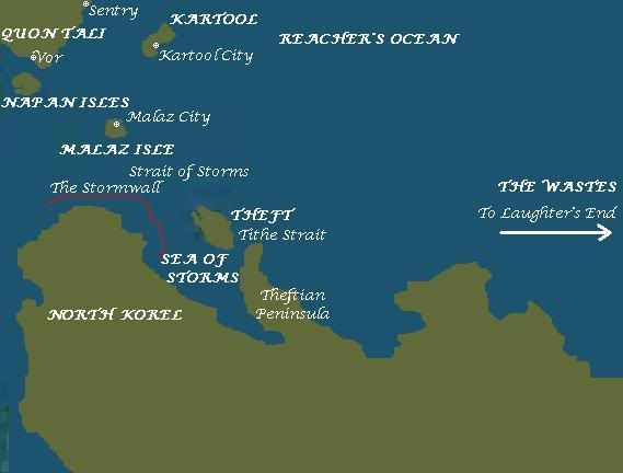
Visit The Wertzone for reviews of SF&F books, DVDs and computer games!
"Try standing out in a winter storm all night and see how tough you are. Start with that. Then go into a bar and pick a fight and see how tough you are. And then go home and break crockery over your head. Start with those three and you'll be good to go."
- Bruce Campbell on how to be as cool as he is
- Bruce Campbell on how to be as cool as he is
#51
ch'arlz

- Lo-Fi Version
-
- Group: Malaz Regular
- Posts: 521
- Joined: 17-May 07
- Location:Northern Virginia USA
Posted 23 June 2007 - 08:05 PM
Werthead;196324 said:
Any information on Laughter's End from the novella? Its location, if it's an island or part of a larger continent? Is it mentioned as being near Korelri or Jacuruku or Assail? What are the 'Red Roads' that are linked to it? Sea lanes?
From page 15:
Quote
The red road that was Laughter's End beckoned... the grim vein, the currents of Mael's very own blood
Werthead;196324 said:
that means placing it with regards to Genabackis becomes problematic (since people would crash into Assail along the way or have to double back on themselves to get to the Seguleh islands).
With this quote and the opening paragraph that CB posted earlier, I think it's clear that between Theft and the islands of the Seguleh and the southern coast of Genabackis lies a vast, unbroken stretch of ocean known as The Wastes, a part of which (closer to Genabackis) is the Red Road of Laughter's End. It's where the dhenrabi come to mate and sharks congregate to feed on vanquished bulls, which probably causes the end of laughing.
#52
Omras Ghum

- Fist
-
- Group: Malaz Regular
- Posts: 212
- Joined: 04-September 05
Posted 23 June 2007 - 09:23 PM
I have a question - i have no quotes to back any of it up but i got the impression that dujeks host kind of came to genabackis from the north because iirc it was the north and north-west coast that was first conquered by the malazan army ... now why would they invade genabackis from there if malaz, seven cities et al lie south and west from that coast? wouldn't it be more likely the malazans should have first arrived at the mid-section of the west-coast of genabackis?
i really never paid much attention to the geographical situation whilst reading the books so my question is most likely VERY foolish yet again... but still - care to answer me?
i really never paid much attention to the geographical situation whilst reading the books so my question is most likely VERY foolish yet again... but still - care to answer me?
#53
Werthead
- God
-
- Group: Malaz Regular
- Posts: 4,260
- Joined: 14-November 05
Posted 24 June 2007 - 12:54 AM
In HoC we learn that Genabaris and the other north-west cities were pretty weak and disorganised before the invasion. I'm guessing the Malazans invaded there as they thought it was a weak spot. Going from GotM, MoI and NoK, they all seem to suggest that the only thing that stopped the Malazans overrunning both Korelri and Genabackis during their initial invasions was the Crimson Guard, suggesting that the Malazans did not see much difficulty taking the whole continent and thus it didn't really matter where they landed.
I also get the feeling that the Malazan army headed for Genabackis mustered on Seven Cities first, and used north-eastern Seven Cities and possibily Otataral Island as staging posts (as they used Malaz Island and then Theft to stage for the invasion of Korelri), which would put them closer to Genabackis' western and north-western coasts.
It is also possible that if there is a clockwise current rotating around Seeker's Deep/Meningalle Ocean then an invasion force launched directly from either Quon Tali or Seven Cities would be carried around to the north coast of Genabackis; an invasion fleet heading for the south coast would have to sail against the current which would take a lot longer. It's also worth noting in GotM that someone says the Malazans did launch simultaneous attacks on both the north-western and north-eastern coasts to capture the Free Cities in a pincer movement.
Visit The Wertzone for reviews of SF&F books, DVDs and computer games!
"Try standing out in a winter storm all night and see how tough you are. Start with that. Then go into a bar and pick a fight and see how tough you are. And then go home and break crockery over your head. Start with those three and you'll be good to go."
- Bruce Campbell on how to be as cool as he is
- Bruce Campbell on how to be as cool as he is
#54
Omras Ghum
- Fist
-
- Group: Malaz Regular
- Posts: 212
- Joined: 04-September 05
Posted 24 June 2007 - 08:35 AM
well, thanks, i guess that settles it - somewhat. but i take it there is no indisputable proof as to genabackis being where it is on your map? wait and see it is then.
#55
Werthead
- God
-
- Group: Malaz Regular
- Posts: 4,260
- Joined: 14-November 05
Posted 24 June 2007 - 12:44 PM
Well, Steven Erikson said it was roughly right. I had to move the continent a bit southwards from the original map to get it into the right place 
Visit The Wertzone for reviews of SF&F books, DVDs and computer games!
"Try standing out in a winter storm all night and see how tough you are. Start with that. Then go into a bar and pick a fight and see how tough you are. And then go home and break crockery over your head. Start with those three and you'll be good to go."
- Bruce Campbell on how to be as cool as he is
- Bruce Campbell on how to be as cool as he is
#56
Omras Ghum
- Fist
-
- Group: Malaz Regular
- Posts: 212
- Joined: 04-September 05
Posted 24 June 2007 - 02:40 PM
Ah, the master himself has spoken... I stand corrected, ... and humbled *bows*.

#58
Hoods Balls

- Malazan Heavy Infantry
-
- Group: Malaz Regular
- Posts: 96
- Joined: 14-August 07
- Location:Above the polar circle
- Interests:Cheating Death, Soldiering, Hunting, Soul Harvesting, Chemistry, Alchemy and Advanced Lipides.
Posted 17 August 2007 - 12:13 PM
Just wanna to say a humble thank you Wert for your excellent work with the maps. The lack of coherrent maps is really annoying. Many of my questions have now been answered.
Thanks!
Thanks!
#59
lamatath

- Recruit
-
- Group: Malaz Regular
- Posts: 4
- Joined: 06-September 07
Posted 06 September 2007 - 10:04 PM
Re-reading blood follows and Lees of Laughterâs End, a number of points came up for me, in relation to the world map which I thought I'd share (worth finally registering an account and posting  )
)
firstly, the debate about whether the first line in 'the lees of laughter's end' is a mistake on Erikson's part.
there are, in the first chapter of TLOLE, some other quotes related to this:
and crucially on page 5
unlikely for him to make the same mistake repeatedly, plus in Blood Follows page 55
so, I would think that this would confirm that they actualy are traveling west.
furthermore in the last chapter of blood follows as they have set sail:
I think this suggests that the tithe straights are those between Malaz island and the stormwall on korel (and that they have bought passage from the stormriders)
further confusing everything, also mentioned in Blood follows is the blood walk straits
Stygg appears to be "just across the strait from Moll" so it would seem obvious that bloodwalk strait is separating theft (at least south east theft where Moll is) from the theft peninsula and the rest of korel.
in RG thereâs a quote about theft too
or just about that.
this implies that they can travel straight east for a distance (don't know how many leagues average 3 days sailing would be) before actualy having to turn north to avoid the straits where the storm lords are (which I think is are the tithe straights)
this also means that even form kartool a straight line cannot be sailed to theft (not too sure about this) nor am I sure on the distance between the two. but it would surely mean that on Wertheadâs map theft should be further east and perhaps in a direct line east from the straights between malaz and korel so that the suncurl could travel due west.
anyone agree?
)firstly, the debate about whether the first line in 'the lees of laughter's end' is a mistake on Erikson's part.
Quote
west of Theft, the Tithe Straight opens out into the Wastes...as far as the Red Road of Laughter's End
there are, in the first chapter of TLOLE, some other quotes related to this:
Quote
she studied the western wastes
and crucially on page 5
Quote
And now, far to the west, Bene saw as her mother had said she would see. the vein of blood. Laughter's End
unlikely for him to make the same mistake repeatedly, plus in Blood Follows page 55
Quote
"and..." Bauchlain refilled his goblet "Book us a passage. Westward, as far as the ship will take us."
so, I would think that this would confirm that they actualy are traveling west.
furthermore in the last chapter of blood follows as they have set sail:
Quote
they were in the troughs, beyond moll bay in the tithe straits
Quote
'Tis a good thing, the appeasement agreed with the storm riders. passage on the seas should not cost us more than a jar or two of blood
I think this suggests that the tithe straights are those between Malaz island and the stormwall on korel (and that they have bought passage from the stormriders)
further confusing everything, also mentioned in Blood follows is the blood walk straits
Quote
for 20 years doing the stygg run down bloodwalk strait
Stygg appears to be "just across the strait from Moll" so it would seem obvious that bloodwalk strait is separating theft (at least south east theft where Moll is) from the theft peninsula and the rest of korel.
in RG thereâs a quote about theft too
Quote
3 days by ship east of kartool, beginning an arc northwards around the straits between Malaz island and korel....on their way to theft
or just about that.
this implies that they can travel straight east for a distance (don't know how many leagues average 3 days sailing would be) before actualy having to turn north to avoid the straits where the storm lords are (which I think is are the tithe straights)
this also means that even form kartool a straight line cannot be sailed to theft (not too sure about this) nor am I sure on the distance between the two. but it would surely mean that on Wertheadâs map theft should be further east and perhaps in a direct line east from the straights between malaz and korel so that the suncurl could travel due west.
anyone agree?
#60
Imperium Corruo

- Lieutenant
-
- Group: Malaz Regular
- Posts: 109
- Joined: 15-November 06
Posted 24 September 2007 - 01:03 AM
I did not read this whole thread, or the one in the Bonehunters forum, so I don't know if this has been covered, if it has I apologize.
I recently got my copy of The Bonehunters, and it has a map fo Quon Tali. At the northern edge of this map there is a distinct area labeled "icefields." When I look at your map, I see that the particular area of Quan Tali is nearly riding the equator. I just wondering what the deal with that is, why are there icefields on the equator, is there an elevation difference in that area?
On a similar note, I remember the Sengar brothers trip to Glacial territory in the first part of MT, and that area appears to be tropical in your map.
I'm not saying your map is wrong, but I'm curious as to this odd geographical phenomena


