Posted 05 May 2007 - 02:36 PM
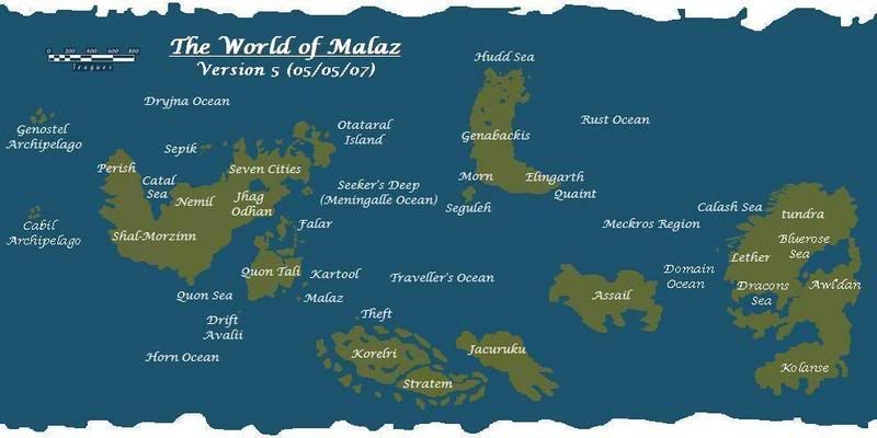
It was straightforward. There are some scans of the map books around so it was just a matter of sizing them so the scale bars all matched and then sticking them on a vaguely Earth-sized planet. Much of the legwork was done by a poster called Jonathan who first tried to do this about two years ago. He scaled the maps to one another (although according to SE Genabackis should be slightly bigger) and came up with the colour scheme. I just moved the continents into the correct positions and coloured them in.
Obviously, the coastlines and sizes for landmasses unmapped in the novels so far are all speculative: Assail, Korel, Jacuruku, western Seven Cities, eastern Genabackis, southern Lether/Kolanse etc.
What would be great is if we could get really high-resolution of the maps seen so far in the books. We could then trace over them with Campaign Cartographer to create fully-scalable, infinitely-zoomable maps with secondary maps (cities), region maps etc linked to the world one. You could switch on layers, so you could flash up a map of the Chain of Dogs' route across Seven Cities or the advance of the allies' army into the Pannion Domin, for example. It would be cool.
Visit
The Wertzone for reviews of SF&F books, DVDs and computer games!
"Try standing out in a winter storm all night and see how tough you are. Start with that. Then go into a bar and pick a fight and see how tough you are. And then go home and break crockery over your head. Start with those three and you'll be good to go."
- Bruce Campbell on how to be as cool as he is
 Help
Help


 (recalls spelling screw-ups in TBH glossary/cast list)


