 Help
Help
Malazan World Map
Unofficial map of the world.
Rate Topic:

#201
 Werthead

- God
-

- Group: Malaz Regular
- Posts: 4,260
- Joined: 14-November 05
Posted 08 March 2011 - 10:58 PM
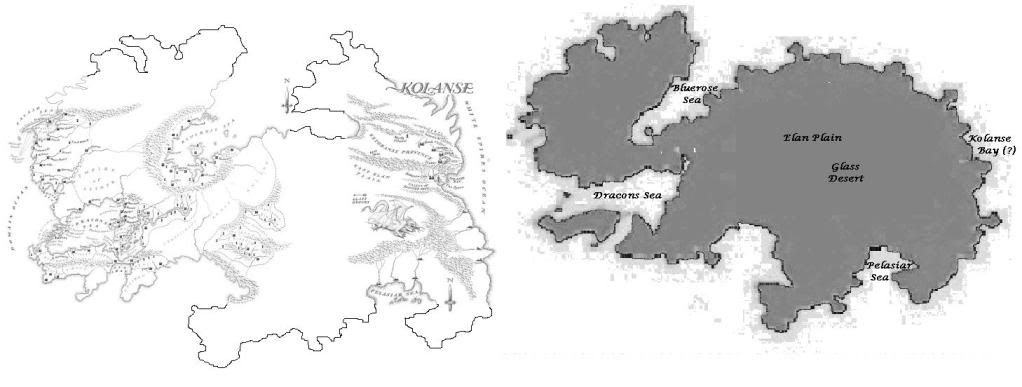
Right, my map on the left, the one from Hetan's world map from upthread on the right. I know that map's rough, but there is enough detail to work from (just).
Visit The Wertzone for reviews of SF&F books, DVDs and computer games!
"Try standing out in a winter storm all night and see how tough you are. Start with that. Then go into a bar and pick a fight and see how tough you are. And then go home and break crockery over your head. Start with those three and you'll be good to go."
- Bruce Campbell on how to be as cool as he is
- Bruce Campbell on how to be as cool as he is
#202
D'rek

- Consort of High House Mafia
-
- Group: Super Moderators
- Posts: 14,645
- Joined: 08-August 07
- Location::
Posted 09 March 2011 - 04:47 AM
 Werthead, on 08 March 2011 - 10:58 PM, said:
Right, my map on the left, the one from Hetan's world map from upthread on the right. I know that map's rough, but there is enough detail to work from (just).
Looks great!
Should we maybe move this thread into the TCG forum since we're discussing Kolanse this much?
Anyways, did we ever have a specific mention of that sea in Kolanse being the Bluerose sea? otherwise you could just close it in on the left side as a landlocked sea and have something very similar to the shape of Hetan's map.
worrywort, on 14 September 2012 - 08:07 PM, said:
I kinda love it when D'rek unleashes her nerd wrath, as I knew she would here. Sorry innocent bystanders, but someone's gotta be the kindling.
#203
Hetan

- Chief Cook and Bottle Washer
-

- Group: Mezla's Thought Police
- Posts: 4,617
- Joined: 29-January 03
Posted 09 March 2011 - 08:52 AM
That's pretty close to be honest - just a few bumps that might need to be evened out, although the map I have is liable to change so I would go with your instincts on that one Wert. Yes that is the Bluerose sea and it's not landlocked - Wert's done a great job with that map.
"He was not a modest man. Contemplating suicide, he summoned a dragon". (Gothos' Folly)- Gothos
#204
mayhem

- Recruit
-
- Group: Malaz Regular
- Posts: 25
- Joined: 04-November 08
Posted 06 June 2011 - 03:34 PM
Sinisdar Toste, on 06 June 2010 - 07:58 PM, said:
Sadist, on 06 June 2010 - 06:25 PM, said:
awesome, thanks Hetan...
now it's just to locate Laederon plateau.
not on the maps, but if Moon's Spawn travelled 1000 leagues in a glacier...well, that WOULD be massive...enough that the north of Genabackis is actually under the polar icecap...
and even if, as many are wont to do, L'oric was exaggerating, say that 1000 is more like 500 leagues,
then Moon's spawn would have been discovered very near the center of the north pole...
then again, I think werty mentioned that the Malazan fleet had invaded from both the eastern and western coasts...so they'd have to have sailed around the continent somehow...
eh...is this making any sense to anyone?
thing is, glaciation once reached as far south as darujhistan. lake azur is a glacial lake, the old jaghra til. the laederon plateau is marked on the genebackis maps in gotm and moi and is roughly in the centre of the northern ice fields. there is some mountains that are quite possibly glaciated to the north of it (where rake and osserc would have found moon`s spawn) and then the coast. which is nowhere near the pole. the glaciation was omtose phellack
as an aside, there doesn`t seem to be any bodies of land close enough to the poles to cause any natural glaciation anyhow. all the glaciers we`ve heard of so far have been OP
Just found this quote from the MoI reread.
'The Jaghut remember Moon's Spawn. I alone am in possession of the relevant scrolls from Gothos's Folly that whisper of the K'Chain Nah'rhuk - the Short-Tails, misbegotten children of the Matrons - who fashioned mechanisms that bound sorcery in ways long lost, who built vast, floating fortresses from which they launched devastating attacks upon their long-tailed kin.
'Oh, they lost in the end. Were destroyed. And but one floating fortress remained, damaged, abandoned to the winds. Gothos believed it had drifted north, to collide with the ice of a Jaghut winter, and was so frozen, trapped for millennia. Until found by the Tiste Andii Lord.
So yes, it would make sense that it drifted north from the battlezones near say Morn to the Laederon Plateau where it got stuck.
#205
Luperci

- Not Bruce Wayne
-
- Group: Malaz Regular
- Posts: 114
- Joined: 20-August 13
- Location:Gotham City
- Interests:Fighting crime and hanging with my Butler
Posted 31 May 2014 - 05:25 PM
How cool would it be if a globe was made of the Malaz world, I know we have pretty accurate maps but like any map its hard to tell how the world really looks in a 2D picture where as in 3D you can see how close the continents really are in relation to the rest of the world. Take for instance our regular ole map of earth, looking at it flat you would never guess that Alaska and Russia are pretty close or Scandinavia and the top part of North America almost touch near the north pole but when stretched out on a 3D globe the whole picture becomes more clear. I for one would pay $$ for an accurate detailed colored Malaz Globe.
The Harder the world, the fiercer the Honor.
-Dancer
-Dancer
#206
D'rek
- Consort of High House Mafia
-
- Group: Super Moderators
- Posts: 14,645
- Joined: 08-August 07
- Location::
Posted 02 June 2014 - 07:00 PM
CapedCrusader, on 31 May 2014 - 05:25 PM, said:
How cool would it be if a globe was made of the Malaz world, I know we have pretty accurate maps but like any map its hard to tell how the world really looks in a 2D picture where as in 3D you can see how close the continents really are in relation to the rest of the world. Take for instance our regular ole map of earth, looking at it flat you would never guess that Alaska and Russia are pretty close or Scandinavia and the top part of North America almost touch near the north pole but when stretched out on a 3D globe the whole picture becomes more clear. I for one would pay $$ for an accurate detailed colored Malaz Globe.
At the very least, I wonder if there is free software online that you can give a custom image to and project it onto the surface of a sphere, and at least get pictures from a few different angles of said sphere? It wouldn't be a physical globe sitting in your house, but I'd like to see how our fan-made world maps would look like put onto a sphere. I did a quick search but didn't find any websites offering this sort of thing, unfortunately.
worrywort, on 14 September 2012 - 08:07 PM, said:
I kinda love it when D'rek unleashes her nerd wrath, as I knew she would here. Sorry innocent bystanders, but someone's gotta be the kindling.
#207
Dadding

- Shaved Knuckle in the Hole
-
- Group: Malaz Regular
- Posts: 365
- Joined: 27-August 13
- Location:Vancouver, British Columbia
Posted 03 June 2014 - 07:15 AM
D, on 02 June 2014 - 07:00 PM, said:
CapedCrusader, on 31 May 2014 - 05:25 PM, said:
How cool would it be if a globe was made of the Malaz world, I know we have pretty accurate maps but like any map its hard to tell how the world really looks in a 2D picture where as in 3D you can see how close the continents really are in relation to the rest of the world. Take for instance our regular ole map of earth, looking at it flat you would never guess that Alaska and Russia are pretty close or Scandinavia and the top part of North America almost touch near the north pole but when stretched out on a 3D globe the whole picture becomes more clear. I for one would pay $ for an accurate detailed colored Malaz Globe.
At the very least, I wonder if there is free software online that you can give a custom image to and project it onto the surface of a sphere, and at least get pictures from a few different angles of said sphere? It wouldn't be a physical globe sitting in your house, but I'd like to see how our fan-made world maps would look like put onto a sphere. I did a quick search but didn't find any websites offering this sort of thing, unfortunately.
I stumbled across this one a while ago.
You might have to play around with the dimensions / aspect ratio and all that, but here's a screen-cap of one I whipped up quickly.

#209
D'iversify

- First Sword
-
- Group: Malaz Regular
- Posts: 647
- Joined: 07-October 10
Posted 29 July 2014 - 12:00 PM
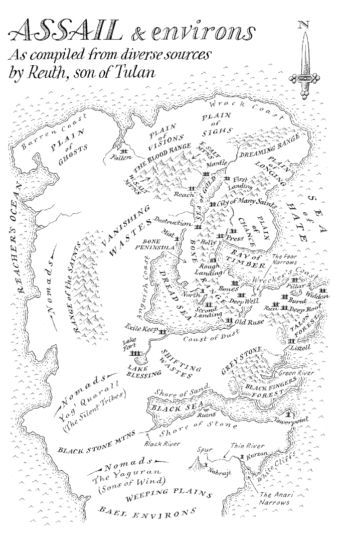
Since we now have an Assail map (for those who haven't seen: http://loopingworld....misc/assail.jpg ), does anyone think this changes anything with our presumed Malazan geography (or should that be Wu-ography?)? Shame Bael isn't covered but still, a nice map, especially compared ot the lacking in detail Jacuruku one.
I am the Onyx Wizards
#210
Gorefest
- Witness
-
- Group: Malaz Regular
- Posts: 2,988
- Joined: 29-May 14
- Location:Sheffield
Posted 05 August 2015 - 05:15 PM
Just wondering, and it may already have been discussed previously but I couldn't find it: the First Empire supposedly had mapped 'the six continents' and 811 islands. Now, I don't have any particular desire to start counting islands, but I believe there are 7 continents (disregarding Umryg and Genostel for the moment). So that would be Quon Tali/Falar, Genabackis, Genabaris, Korel/Stratem, Jacuruku, Lether/Kolanse, and Assail.
So what is happening there? Is it simply a mistake by SE? Was the First Empire unaware of one of the continents and, if so, which one (Assail?)? Or is this remark dating back to times when presumably Jacuruku and Korel/Stratem were still attached, i.e. before the Fall? Or is there some other reason?
So what is happening there? Is it simply a mistake by SE? Was the First Empire unaware of one of the continents and, if so, which one (Assail?)? Or is this remark dating back to times when presumably Jacuruku and Korel/Stratem were still attached, i.e. before the Fall? Or is there some other reason?
Yesterday, upon the stair, I saw a man who wasn't there. He wasn't there again today. Oh, how I wish he'd go away.
#211
worry

- Master of the Deck
-
- Group: Malaz Regular
- Posts: 14,981
- Joined: 24-February 10
- Location:the buried west
Posted 05 August 2015 - 11:07 PM
I think Genebaris is just a port city on Genebackis. Not sure if the Seven Cities continent has a name. It's possible a destroyed Jacuruku was unmappable. Or maybe Quon Tali was treated more like Greenland than a continent.
They came with white hands and left with red hands.
#212
Gorefest
- Witness
-
- Group: Malaz Regular
- Posts: 2,988
- Joined: 29-May 14
- Location:Sheffield
Posted 06 August 2015 - 09:36 AM
Pfff, where's my brain. Seven Cities/Perish continent I meant, of course.
Yesterday, upon the stair, I saw a man who wasn't there. He wasn't there again today. Oh, how I wish he'd go away.
#213
Mentalist

- Martyr of High House Mafia
-

- Group: High House Mafia
- Posts: 9,988
- Joined: 06-June 07
- Location:'sauga/GTA, City of the Lion
- Interests:Soccer, Chess, swimming, books, misc
- Junior Mafia Mod
Posted 16 October 2015 - 08:12 PM
Gorefest, on 05 August 2015 - 05:15 PM, said:
Just wondering, and it may already have been discussed previously but I couldn't find it: the First Empire supposedly had mapped 'the six continents' and 811 islands. Now, I don't have any particular desire to start counting islands, but I believe there are 7 continents (disregarding Umryg and Genostel for the moment). So that would be Quon Tali/Falar, Genabackis, Genabaris, Korel/Stratem, Jacuruku, Lether/Kolanse, and Assail.
So what is happening there? Is it simply a mistake by SE? Was the First Empire unaware of one of the continents and, if so, which one (Assail?)? Or is this remark dating back to times when presumably Jacuruku and Korel/Stratem were still attached, i.e. before the Fall? Or is there some other reason?
So what is happening there? Is it simply a mistake by SE? Was the First Empire unaware of one of the continents and, if so, which one (Assail?)? Or is this remark dating back to times when presumably Jacuruku and Korel/Stratem were still attached, i.e. before the Fall? Or is there some other reason?
First Empire was around roughly same time as Kallorean empire, no?
Maybe they counted Korel + Jakuruku as one continent, before the Fall?
The problem with the gene pool is that there's no lifeguard
THE CONTESTtm WINNER--чемпіон самоконтролю
THE CONTESTtm WINNER--чемпіон самоконтролю
Jump Around, on 23 October 2011 - 11:04 AM, said:
And I want to state that Ment has out-weaseled me by far in this game.


