 Help
Help
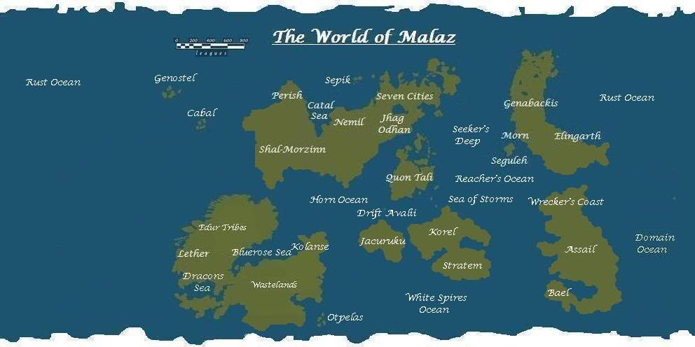
Is Korelri really that small (the size of Quon Tali)? I recall SE saying it should be bigger (and so should Genabackis) on the very first map I did.
Malazan World Map
Unofficial map of the world.
Rate Topic:

#21
 Werthead

- God
-

- Group: Malaz Regular
- Posts: 4,260
- Joined: 14-November 05
Posted 23 January 2010 - 01:18 PM
Visit The Wertzone for reviews of SF&F books, DVDs and computer games!
"Try standing out in a winter storm all night and see how tough you are. Start with that. Then go into a bar and pick a fight and see how tough you are. And then go home and break crockery over your head. Start with those three and you'll be good to go."
- Bruce Campbell on how to be as cool as he is
- Bruce Campbell on how to be as cool as he is
#22
Malaclypse

- Banned User
-

- Group: Banned Users
- Posts: 1,350
- Joined: 24-August 16
Posted 23 January 2010 - 01:35 PM
Regarding the pattern of Malazan exploration/conquest, I'd imagine that the ongoing struggle with the Korel keeps them from going further south or west from Quon Tali. SE's map is clearly meant to wrap-around, as Korel actually bridges the gap. My mock-up may misrepresent the distance between Genabackis and Seven Cities/Quon Tali as they're really quite close. Anyway, I don't see a problem with the Malazans concentrating on expanding north and east.
I want to stress that the part of Seven Cities that we've seen in the books is only the extreme eastern bit, encompassing less than a third of the entire continent. It looks to me like the Malazans went directly north to Seeven Cities and then directly east to northern Genabackis and that's as far as they got.
Why would they carry on south to Jacuruku or SW to Lether, leaving the obviously formidable Korelan navy behind to menace their supply lines?
After hunting for some quotes:
Gesler and Kulp, having just found Binadas' corpse on the Silanda in DG, comment that nobody has returned from Drift Avalii so their information about the Tiste Andii there is questionable. Now Drift Avalii is very close to the SW coast of Quon Tali so if they haven't even explored that far, it's no surprise that they haven't visited Jacuruku or Lether. Also note in the quote below that Kulp implies that the Malazans are completely unaware of Lether.
Obviously this quote is problematic...I'm going to spend some time on this problem and hopefully add something useful later...
edit: cross-posted with Werthead.
To answer you, yeah, Korelri appears smaller than Quon Tali actually, though, as stated above, on this map Korelri wraps around from right to left and it's a bit indistinct on the left edge but it's certainly no larger then Quon Tali. And yeah, Genabackis should be bigger.
I want to stress that the part of Seven Cities that we've seen in the books is only the extreme eastern bit, encompassing less than a third of the entire continent. It looks to me like the Malazans went directly north to Seeven Cities and then directly east to northern Genabackis and that's as far as they got.
Why would they carry on south to Jacuruku or SW to Lether, leaving the obviously formidable Korelan navy behind to menace their supply lines?
After hunting for some quotes:
Gesler and Kulp, having just found Binadas' corpse on the Silanda in DG, comment that nobody has returned from Drift Avalii so their information about the Tiste Andii there is questionable. Now Drift Avalii is very close to the SW coast of Quon Tali so if they haven't even explored that far, it's no surprise that they haven't visited Jacuruku or Lether. Also note in the quote below that Kulp implies that the Malazans are completely unaware of Lether.
Quote
. There was a map there, showing a land he could not recognize: a ragged coastline of fjords studded with cursory sketches of pine trees. Inland was a faint whitewash, as of ice or snow. A course had been plotted, striking east from the jagged shoreline, then southward across a vast ocean. The Malazan Empire purported to have world maps, but they showed nothing like the land he saw here. The Empire’s claim to dominance suddenly seemed pathetic.
Obviously this quote is problematic...I'm going to spend some time on this problem and hopefully add something useful later...
edit: cross-posted with Werthead.
To answer you, yeah, Korelri appears smaller than Quon Tali actually, though, as stated above, on this map Korelri wraps around from right to left and it's a bit indistinct on the left edge but it's certainly no larger then Quon Tali. And yeah, Genabackis should be bigger.
This post has been edited by Malaclypse: 23 January 2010 - 01:42 PM
#23
Jorram

- High Fist
-
- Group: Malaz Regular
- Posts: 383
- Joined: 07-June 04
Posted 23 January 2010 - 01:59 PM
The only real problem with the new map that cant be solved by moving around and correct sphere mapping is the position of Bael. It can't be simultaneously next to Jacuruku and Assail now. Why was that necessary, again? I mean Bael is supposed to be close to Assail but our only reason to put it close to Jacuruku is that the Guard was there. But the Guard travelled for many years and also on Assail (they picked the Lost brothers after all).
#24
Malaclypse
- Banned User
-
- Group: Banned Users
- Posts: 1,350
- Joined: 24-August 16
Posted 23 January 2010 - 02:11 PM
 Jorram, on 23 January 2010 - 01:59 PM, said:
The only real problem with the new map that cant be solved by moving around and correct sphere mapping is the position of Bael. It can't be simultaneously next to Jacuruku and Assail now. Why was that necessary, again? I mean Bael is supposed to be close to Assail but our only reason to put it close to Jacuruku is that the Guard was there. But the Guard travelled for many years and also on Assail (they picked the Lost brothers after all).
On this map, Bael is simply the southern part of the continent of Assail, they are not disconnected. As indicated in my mock-up, Assail is a long skinny continent.
#25
Werthead
- God
-
- Group: Malaz Regular
- Posts: 4,260
- Joined: 14-November 05
Posted 23 January 2010 - 03:29 PM
I took Kyle's statements in RotCG that you can see the forbidding coastline of Assail from Bael to mean that Bael was a separate, much smaller landmass within viewing distance of the Assail coast. Of course, I suppose that Bael could be a peninsular subcontinent (as Stratem is to Korelri?) which wraps around and comes back in again close to the coast of the rest of Assail?
The more I think of it, the more I think Jacuruku's relationship to Korelri/Assail was not mentioned in RotCG. I think I might have gotten mixed up in the Bael/Stratem/Korel/Assail relationship and the presence of Iron Bars, whom we last saw on Jacuruku in RG before somehow ending up on a ship not too far from Genabackis in RotCG.
The more I think of it, the more I think Jacuruku's relationship to Korelri/Assail was not mentioned in RotCG. I think I might have gotten mixed up in the Bael/Stratem/Korel/Assail relationship and the presence of Iron Bars, whom we last saw on Jacuruku in RG before somehow ending up on a ship not too far from Genabackis in RotCG.
Visit The Wertzone for reviews of SF&F books, DVDs and computer games!
"Try standing out in a winter storm all night and see how tough you are. Start with that. Then go into a bar and pick a fight and see how tough you are. And then go home and break crockery over your head. Start with those three and you'll be good to go."
- Bruce Campbell on how to be as cool as he is
- Bruce Campbell on how to be as cool as he is
#26
Malaclypse
- Banned User
-
- Group: Banned Users
- Posts: 1,350
- Joined: 24-August 16
Posted 23 January 2010 - 04:39 PM
Werthead, on 23 January 2010 - 03:29 PM, said:
Of course, I suppose that Bael could be a peninsular subcontinent (as Stratem is to Korelri?) which wraps around and comes back in again close to the coast of the rest of Assail?
This

Quote
The more I think of it, the more I think Jacuruku's relationship to Korelri/Assail was not mentioned in RotCG. I think I might have gotten mixed up in the Bael/Stratem/Korel/Assail relationship and the presence of Iron Bars, whom we last saw on Jacuruku in RG before somehow ending up on a ship not too far from Genabackis in RotCG.
When Iron Bars takes over the slave ship, he commands the tillerman to head SW, 'around the cape to Stratem', which would mean that they are somewhere near the Korelan coast, north of Stratem. Am I missing something that suggests that they are ever close to Genabackis? The Seguleh are notoriously fearless and they're seacrhing for something that was stolen from them long ago so I don't think it's unreasonable that they may have strayed quite far from their homeland.
Anyway, I've been playing around with my mock-up, trying to make sense of the relevant quotes that I'm aware of regarding Malazan geography and I've come up with this:
 rough_map_revised.jpg (86.36K)
Number of downloads: 52
So if Tomad and Binadas set off from Edur lands, they can go east along the Lether coast, in keeping with the charts found by Kulp and Gesler on the Silanda. We know that Tomad charged Binadas with searching for Trull and that the Silanda was given to him after its capture. We also know that some Andii from Drift Avalii were sailing on the Silanda in search of Anomander Rake (this from Nimander or Phaed in BH). The blue circle indicates roughly the region where I suspect the Silanda is captured by the Edur. The Edur were active in this area, engaging Malazan forces and assaulting Drift Avalii. I submit that the charts found on the Silanda mark Tomad's course south, between Jacuruku and Lether, emerging at the top of the map near Sepik, where we know Tomad landed and found 'degenerate' Edur. East, then south for Tomad, works great with this map. I think Binadas enters the Nascent shortly after commandeering the Silanda so has kept a record of Tomad's projected course so he can find him afterwards.
The Bonehunters leave Seven Cities shortly after the debacle at Y'Ghatan, placing them on the northern coast. Their subsequent route is well-documented and after the conflict in Malaz City they head northeast and end up reaching Lether. it's very rough I admit, but is it not plausible? there's a quote that says they were three days east of Kartool heading towards Korel, which must be in error so if we can disregard that, I think it works.
ETA the aforementioned quote that must not be true:
Quote
the ragged fleet, flanked by the Perish Thrones of War, was three days east of Kartool, beginning a northward wending arc to take them round the tumultuous, deadly straits between Malaz Island and the coast of Korelri
This post has been edited by Malaclypse: 23 January 2010 - 04:47 PM
#27
Werthead
- God
-
- Group: Malaz Regular
- Posts: 4,260
- Joined: 14-November 05
Posted 24 January 2010 - 02:10 AM
Some reasonable thoughts except that you're forgetting that world maps only wrap on an east-west axis. If you go off the eastern edge of a map you reappear on the western, but if you go off the northern you reappear on the northern edge 180 degrees away, same for the southern. You don't sail pass the northern tip of Canada and then reappear near Chile You'd reappear on the map somewhere north of Russia.
In RG the Bonehunters say that they were a year at sea, which means that they must have gone the 'long way around' (east rather than west) across the vast stretch of water mentioned in Lees of Laughter's End, around Assail and then to Lether. If we assume that's how they did it (presumably to avoid passing through the Malazan and Edur ships battling near Drift Avalii), then that same vast stretch of water may account for the description in DHG.
I always thought the description in DHG was odd in that it appeared to describe the Edur lands on Lether (the interior ice fields, pine forest near the coast, fjords along the coast), but they were on the west coast, not the east. If we change east to west, then you can make the description work by assuming they travelled west, across the Rust Ocean (which looks like it may now be the biggest stretch of water on the planet), around the north coast of Genabackis and then reaching Seven Cities that way.
This is intriguing enough for me to re-attempt doing the map. Do we know if Stonewielder is going to have a map of Korelri?
Ooh, important-ish question: is the Bluerose Sea an inland sea or does it open out to the ocean as I theorised?
You'd reappear on the map somewhere north of Russia.In RG the Bonehunters say that they were a year at sea, which means that they must have gone the 'long way around' (east rather than west) across the vast stretch of water mentioned in Lees of Laughter's End, around Assail and then to Lether. If we assume that's how they did it (presumably to avoid passing through the Malazan and Edur ships battling near Drift Avalii), then that same vast stretch of water may account for the description in DHG.
I always thought the description in DHG was odd in that it appeared to describe the Edur lands on Lether (the interior ice fields, pine forest near the coast, fjords along the coast), but they were on the west coast, not the east. If we change east to west, then you can make the description work by assuming they travelled west, across the Rust Ocean (which looks like it may now be the biggest stretch of water on the planet), around the north coast of Genabackis and then reaching Seven Cities that way.
This is intriguing enough for me to re-attempt doing the map. Do we know if Stonewielder is going to have a map of Korelri?
Ooh, important-ish question: is the Bluerose Sea an inland sea or does it open out to the ocean as I theorised?
This post has been edited by Werthead: 24 January 2010 - 02:24 AM
Visit The Wertzone for reviews of SF&F books, DVDs and computer games!
"Try standing out in a winter storm all night and see how tough you are. Start with that. Then go into a bar and pick a fight and see how tough you are. And then go home and break crockery over your head. Start with those three and you'll be good to go."
- Bruce Campbell on how to be as cool as he is
- Bruce Campbell on how to be as cool as he is
#28
Werthead
- God
-
- Group: Malaz Regular
- Posts: 4,260
- Joined: 14-November 05
Posted 24 January 2010 - 03:00 AM
A rough throwing together of some of the ideas being discussed here.
Korelri is still much too big, I know, and I'm not keen on moving the supposedly-arid Seven Cities that far north, but that seems to be the only way to make it work (it does sit Quon Tali on the equator though, which for some reason I thought was its most likely location). It does make the world a bit more evened out, as previous maps had the planet being very heavy on the southern hemisphere.
I've probably made Assail too big as well, and ended up with the ocean west of Lether being absolutely vast. Whilst that helps with the earlier descriptions of a vast sea needing to be crossed to get there, that might be going overboard.
Visit The Wertzone for reviews of SF&F books, DVDs and computer games!
"Try standing out in a winter storm all night and see how tough you are. Start with that. Then go into a bar and pick a fight and see how tough you are. And then go home and break crockery over your head. Start with those three and you'll be good to go."
- Bruce Campbell on how to be as cool as he is
- Bruce Campbell on how to be as cool as he is
#29
Abalieno

- Fist
-
- Group: Malaz Regular
- Posts: 249
- Joined: 08-June 08
Posted 24 January 2010 - 03:24 AM
You should rescale Lether and Assail at 80% and cut some of that ocean. Is there a reason why the map has to look so wide?
#MrSkimpole
Feed then or perish. Life is but a search for gardens and gentle refuge, and here I sit waging the sweetest war, for I shall not die while a single tale remains to be told. Even the gods must wait spellbound.
Crack'd Pot Trail
Feed then or perish. Life is but a search for gardens and gentle refuge, and here I sit waging the sweetest war, for I shall not die while a single tale remains to be told. Even the gods must wait spellbound.
Crack'd Pot Trail
#30
D'rek

- Consort of High House Mafia
-

- Group: Super Moderators
- Posts: 14,645
- Joined: 08-August 07
- Location::
Posted 24 January 2010 - 04:12 AM
Threw on some journeys for visualization's sake:
mala-map-v8.jpg (111.3K)
Number of downloads: 30
light green is Karsa's journey
pink is Kyle
orange is Iron Bars (a bit weird that he went around Korel...)
red is the 14th army returning to Quon Tali (crap I just remembered - they teleport from west of 7C to south of QT)
grey is Grey Swords
they ever describe what direction the 14th Army went to get to Lether after they left Theft? I always had it in my head they were going East, but I don't know if there's any actual reference to that.
I'd also point out that the Silanda didn't need to be captured around Drift Avalii, the Edur fleets had been around for some time by tBH so the map showing the north-east journey from Lether to Quon Tali could be from anytime and any of the Edur fleets' journeys.
This post has been edited by D'rek: 24 January 2010 - 04:16 AM
worrywort, on 14 September 2012 - 08:07 PM, said:
I kinda love it when D'rek unleashes her nerd wrath, as I knew she would here. Sorry innocent bystanders, but someone's gotta be the kindling.
#31
Werthead
- God
-
- Group: Malaz Regular
- Posts: 4,260
- Joined: 14-November 05
Posted 24 January 2010 - 04:26 AM
Abalieno, on 24 January 2010 - 03:24 AM, said:
You should rescale Lether and Assail at 80% and cut some of that ocean. Is there a reason why the map has to look so wide?
I didn't create the original dimensions of the map, that was another poster on the Malazanempire boards four or five years ago. His approach was to start off by assuming that Malazworld was the same size as Earth, so assuming the 1 league = 3 miles thing is accurate, the map has the same dimensions (give or take) as a map of Earth. If the planet is significantly larger or smaller, than all bets are off.
Visit The Wertzone for reviews of SF&F books, DVDs and computer games!
"Try standing out in a winter storm all night and see how tough you are. Start with that. Then go into a bar and pick a fight and see how tough you are. And then go home and break crockery over your head. Start with those three and you'll be good to go."
- Bruce Campbell on how to be as cool as he is
- Bruce Campbell on how to be as cool as he is
#32
Abalieno
- Fist
-
- Group: Malaz Regular
- Posts: 249
- Joined: 08-June 08
Posted 24 January 2010 - 05:03 AM
It's not a matter of dimensions, more of aspect ratio.
The map you now made breaks the scheme we got from Erikson. Because his map was cut east of Seven Cities but it DID show the space EAST of Genabackis toward Seven Cities continent, and there isn't that much sea between them.
I think the main point here is not to have an idea of dimensions compared to earth. The first priority is to understand how continents in the Malaz world relate to each other in order to support the story. So more than match a map template they should match the story as close as possible.
This is again a modification I made started from yours, if I can:
I still try to position Lether in a way that it's reasonably further away. It's reasonable that the conquest moves the way it did, but if Lether is really that close then at the very least it should be known. Since it's not known and represents a kind of exotic continent I moved it further away, but still within the official scheme we got. This is story wise the scheme that makes sense the most and the map actually looks more organic and plausible.
Accordingly to the scheme I also wonder why you made Genabackis "banana" shaped like that since it seems to have just an vertical shape in the scheme.
This post has been edited by Abalieno: 24 January 2010 - 06:29 AM
#MrSkimpole
Feed then or perish. Life is but a search for gardens and gentle refuge, and here I sit waging the sweetest war, for I shall not die while a single tale remains to be told. Even the gods must wait spellbound.
Crack'd Pot Trail
Feed then or perish. Life is but a search for gardens and gentle refuge, and here I sit waging the sweetest war, for I shall not die while a single tale remains to be told. Even the gods must wait spellbound.
Crack'd Pot Trail
#33
Abyss

- abyssus abyssum invocat
-

- Group: Administrators
- Posts: 23,019
- Joined: 22-May 03
- Location:The call is coming from inside the house!!!!
- Interests:Interesting.
Posted 24 January 2010 - 06:02 AM
I keep thinking Assail should be more distant but i suppose the Wreckers Coast and the Stormriders go a long way to keeping it isolated even if it isn't.
I like the versions that try to trace routes from the stories. it's a nice touch for perspective.
As a general note, i know it's tiny, but perspective-wise i think it would be useful to have Malaz Island marked in.
- Abyss, can read a map... tho not necessarily follow one...
I like the versions that try to trace routes from the stories. it's a nice touch for perspective.
As a general note, i know it's tiny, but perspective-wise i think it would be useful to have Malaz Island marked in.
- Abyss, can read a map... tho not necessarily follow one...
THIS IS YOUR REMINDER THAT THERE IS A
'VIEW NEW CONTENT' BUTTON THAT
ALLOWS YOU TO VIEW NEW CONTENT
'VIEW NEW CONTENT' BUTTON THAT
ALLOWS YOU TO VIEW NEW CONTENT
#34
Jorram
- High Fist
-
- Group: Malaz Regular
- Posts: 383
- Joined: 07-June 04
Posted 24 January 2010 - 09:39 AM
I also think that Assail should be moved further southeast. Other than that I pretty much agree with the last version (the one by Albalieno). To me Korel would be more archipelago like on the shores, after all it was pretty much destroyed by the Fall and I kind of remember descriptions of its northern coast being more island-y. Agree that Malaz Island and possibly Theft should be marked on the map. Bael seems to be too far away from Stratem although thats not necessarily wrong. But maybe Assail isnt so vertical and the southern tip is further slipped to the west.
Agreed about Lether having to be further away. The Albalieno map has it about right methinks.
I dont think we should go wild with making Korel and Jacuruku small
Agreed about Lether having to be further away. The Albalieno map has it about right methinks.
I dont think we should go wild with making Korel and Jacuruku small
#35
Throne of War
- Renegade
-
- Group: Malaz Regular
- Posts: 79
- Joined: 28-June 09
- Location:Your mom's house.
- Life in every breath.
Posted 24 January 2010 - 02:42 PM
I think Joram's got it right. I love the maps you guys do and they really help me to visualize. I have no problems with Genabackis' shape or the size of any continents really. However, I do think Assail should be a just a bit closer to Leather to make it a little more believable for Iron Bars and the boys head that way after 'escaping'. And maybe Leather should have a little more ocean between it and it's neighbors to lend a little more isolation. But whatever, I love the maps anyway they come about. Keep 'em coming, please!
#36
Sinisdar Toste

- Dead Serious
-

- Group: Malaz Regular
- Posts: 3,851
- Joined: 14-July 07
- Location:The C-Hood
Posted 24 January 2010 - 08:17 PM
Jorram, on 24 January 2010 - 09:39 AM, said:
I dont think we should go wild with making Korel and Jacuruku small 
yeah, looking at jacuruku on this map kind of makes kallors empire seem... not so badass somehow, and that is a feeling i do not like.
There's a fine line between genius and insanity. I have erased this line.
- Oscar Levant
- Oscar Levant
#37
Werthead
- God
-
- Group: Malaz Regular
- Posts: 4,260
- Joined: 14-November 05
Posted 24 January 2010 - 11:16 PM
We know Genabackis extends further east and south than on the maps as that is where Elingarth and Morn are located. The exact shape of the landmass is unknown however (aside from those with access to the real map), as the south and east coasts could just be off the maps in MoI and GotM, making it much more of a vertical continent.
The new map I posted was very rough, which is why I didn't bother filling in all the names again. I'm not doing that repeatedly if several new iterations of the map are needed.
The new map I posted was very rough, which is why I didn't bother filling in all the names again. I'm not doing that repeatedly if several new iterations of the map are needed.
Visit The Wertzone for reviews of SF&F books, DVDs and computer games!
"Try standing out in a winter storm all night and see how tough you are. Start with that. Then go into a bar and pick a fight and see how tough you are. And then go home and break crockery over your head. Start with those three and you'll be good to go."
- Bruce Campbell on how to be as cool as he is
- Bruce Campbell on how to be as cool as he is

#39
Werthead
- God
-
- Group: Malaz Regular
- Posts: 4,260
- Joined: 14-November 05
Posted 25 January 2010 - 01:53 AM
maro, on 25 January 2010 - 12:33 AM, said:
Does the Edur lands in Letheras only have Ice due to Jaghut Sorcery?
Yes. That's why they melt after the Jaghut sorcery disappears.
Visit The Wertzone for reviews of SF&F books, DVDs and computer games!
"Try standing out in a winter storm all night and see how tough you are. Start with that. Then go into a bar and pick a fight and see how tough you are. And then go home and break crockery over your head. Start with those three and you'll be good to go."
- Bruce Campbell on how to be as cool as he is
- Bruce Campbell on how to be as cool as he is


