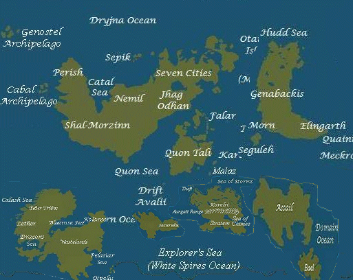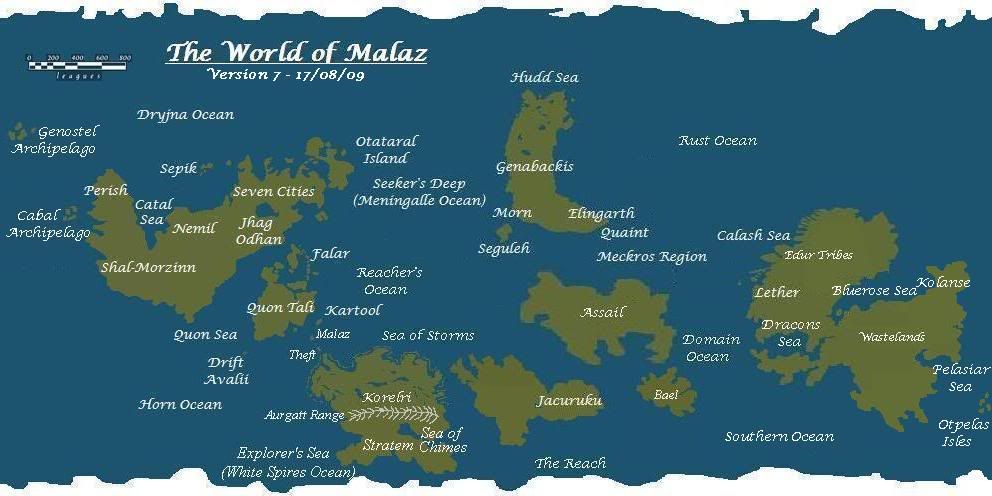
Malazan World Map Unofficial map of the world.
#1
Posted 23 October 2009 - 08:50 PM
The latest instalment in the franchise:
This one required some very minor moving around of all the landmasses further west so I could fit the required greater eastern extent of Lether into the picture.
Visit The Wertzone for reviews of SF&F books, DVDs and computer games!
"Try standing out in a winter storm all night and see how tough you are. Start with that. Then go into a bar and pick a fight and see how tough you are. And then go home and break crockery over your head. Start with those three and you'll be good to go."
- Bruce Campbell on how to be as cool as he is
#2
Posted 23 October 2009 - 08:55 PM
Garsh i love maps! and Garsh werthead makes great maps!
GARSH!
GARSH!
There's a fine line between genius and insanity. I have erased this line.
- Oscar Levant
- Oscar Levant
#3
Posted 26 October 2009 - 10:19 AM
Werthead, on 23 October 2009 - 08:50 PM, said:
The latest instalment in the franchise:
This one required some very minor moving around of all the landmasses further west so I could fit the required greater eastern extent of Lether into the picture.
Its a fantastic effort! Tthe only problem that I can see is that the Edur range is slap bang in the middle of the equator, when it mentions repeatedly that they're surrounded by artic conditions its enroaching glaciers coming down from the north. e.g. when Trull and co. have that run in with the Jeck, snowing ALL the time, ice beneath them to depths of kilometres.
Otherwise spot on as far as I can see!
#4
Posted 26 October 2009 - 10:51 AM
Osseric, on 26 October 2009 - 10:19 AM, said:
Its a fantastic effort! Tthe only problem that I can see is that the Edur range is slap bang in the middle of the equator, when it mentions repeatedly that they're surrounded by artic conditions its enroaching glaciers coming down from the north. e.g. when Trull and co. have that run in with the Jeck, snowing ALL the time, ice beneath them to depths of kilometres.
Otherwise spot on as far as I can see!
Weren't those ice fields created by Gothos's ritual in the MT prologue?
Avoid being seen as racist by saying, "I'm not a racist, but ..." prior to making a racist comment.
#5
Posted 26 October 2009 - 07:47 PM
Wert, the map is looking real good.
I do think, however, that the Lether landmass would be further away from Genabackis.
#6
Posted 26 October 2009 - 10:33 PM
Great work, Wert
However, I'm not sure about the way you moved Assail so much to the south.
It's in the middle of every possible trade route imaginable now. it's hard to believe there'd be that little info on the place if it's literally in the middle of the world.
I think the way it was bofore (east of Genabackis, in the northern Hemisphere) may be more fitting, (like right in that spot that says "rust Ocean") with Bael maybe being at the extreme south-west, so that it's conceivably closer to Jacuruku.
#7
Posted 26 October 2009 - 10:59 PM
The ice fields in Lether are of magical origin, as are the ice fields in Quon Tali. Seriously, people keep asing this every time a new map goes up and it always bemuses me. The ice fields in Lether are unnatural, that's why once the magical effects are removed they start melting and flooding into the sea, inundating the Shake islands and causing major problems in RG.
Assail lies between Lether and Jacuruku as is mentioned in MT, RG and RotCG, and Bael, whose coast is within visual range of Assail's coast, has to lie quite close to Jacuruku for reasons revealed in RotCG.
Also, Assail is not unknown at all. Lots of people know about it. Even a common Malazan soldier mentions (in TBH I believe) the Wrecker's Coast off Assail being dangerous. However, due to Assail's reputation no-one travels there at all. The continent is specifically off-limits to Malazan ships and citizens, and it sounds like everyone else avoids it or travels there and presumably promptly dies (or, if you are Crimson Guard, barely survive to escape).
The size of the map is fixed, as it is meant to be approximately the size of the Earth at the equator. The planet could be bigger or smaller, but there's no real way to tell.
This post has been edited by Werthead: 26 October 2009 - 11:00 PM
Visit The Wertzone for reviews of SF&F books, DVDs and computer games!
"Try standing out in a winter storm all night and see how tough you are. Start with that. Then go into a bar and pick a fight and see how tough you are. And then go home and break crockery over your head. Start with those three and you'll be good to go."
- Bruce Campbell on how to be as cool as he is
#8
Posted 26 October 2009 - 11:09 PM
hmm, I suppose I need to re-rear RotCG then.
in that case, great job!
#9
Posted 30 October 2009 - 07:54 AM
Dang... the image is blocked at work so I can't see it...
But thanks any way Wert... I've been meaning to ask if you were going to do a post-DoD version of this.
Can't wait to get home and see it
But thanks any way Wert... I've been meaning to ask if you were going to do a post-DoD version of this.
Can't wait to get home and see it
Forum Member from the Old Days. Alive, but mostly inactive/ occasionally lurking
#10
Posted 22 January 2010 - 01:33 PM
As I mentioned in another thread, I have a copy of a world map hand-drawn by SE. It's printed from a photo of the drawing. I cropped it into two halves then printed it out on two sheets of A4 and joined them together to get a nice big image. SE did say that he was working on a new version, so take it with a grain of salt but I might be able to assist this effort, worthy as it is.
First, the Malazan world is bigger than Earth, or at least it appears so. This map looks squashed and cramped by comparison, no offense
I don't have the collection of quotes that you've used to create this map, but I'd be interested in having a look if you don't mind sharing Werthead.
Anyway, using my meagre skills I made this:
rough_map.jpg (40.73K)
Number of downloads: 137
I've tried to keep it to scale and I think it's pretty close. Hope this helps
#11
Posted 22 January 2010 - 05:53 PM
i think my brain just tried to turn itself inside out. am i correct in interpreting this as saying that kolanse is south-west, or even south of shal-morzinn?
There's a fine line between genius and insanity. I have erased this line.
- Oscar Levant
- Oscar Levant
#12
Posted 22 January 2010 - 06:06 PM
Shal Morzin is on the southernmost tip of Seven Cities and Kolanse is on the east coast of Lether, so southeast. Is there something controversial about that?
#13
Posted 22 January 2010 - 06:08 PM
i think i'm just being confused by the placement of the lether continent directly beneath the seven cities continent. presumably the actual map is clearer
edit: also i guess i'll have to stop using werts maps as my comparison for geography
This post has been edited by Sinisdar Toste: 22 January 2010 - 06:10 PM
There's a fine line between genius and insanity. I have erased this line.
- Oscar Levant
- Oscar Levant
#14
Posted 22 January 2010 - 06:17 PM
I'm pretty sure Wert will be able to produce something suitable with the new information.
He's done such a great job with the World Map, I'm really looking forward to seeing his next version.
"He was not a modest man. Contemplating suicide, he summoned a dragon". (Gothos' Folly)- Gothos
#15
Posted 22 January 2010 - 06:24 PM
Sinisdar Toste, on 22 January 2010 - 06:08 PM, said:
i think i'm just being confused by the placement of the lether continent directly beneath the seven cities continent. presumably the actual map is clearer
edit: also i guess i'll have to stop using werts maps as my comparison for geography
This mock-up is reasonably close in terms of distance and scale to SE's map. Remember the parts of the Seven Cities continent that we've visited in the books so far are on the extreme eastern end and it's a big continent
#16
Posted 23 January 2010 - 01:35 AM
Lether is south of Western Not-Seven Cities-But-The-Same-Landmass?
What the %&%*!"^&*%£*"!!!! There's a huge ocean (Malazworld's Pacific, I thought) between them, as relayed in DHG and TBH. The boarders of the Silanah find a map depicting a vast ocean west of the entire Seven Cities continent and sea-lanes leading to an unknown land (later presumed to be Lether). Not to mention that the Malazan Empire would have had a far easier time of it invading north-eastern Lether or northern Jacuruku rather than Genabackis, which on this (admittedly not exacting) map looks much further away.
We probably don't really need Malazworld to be bigger than Earth (unless SE decides it is), we just need something to put the map onto a sphere. Putting world maps onto a square piece of paper always results in the scale looking messed up, especially a reasonable distance north and south of the equator.
Jacuruku being between Lether and Korelri also works if you solely take into account the accounts from MT/RG (Team Iron Bars being dropped off on Jacuruku to fight their way across the continent back to Korelri), but then makes no sense from RotCG, where Iron Bars is actually near Genabackis, which doesn't make sense with this map, but sort of works if it's the other way round, since he could have gotten sidetracked on Jacuruku, shot off to the north somewhere, ended up near Genabackis and resumed his course back to Korelri later on.
Obviously Word of God is Word of God but this really doesn't add up with the in-text information we've had so far.
This post has been edited by Werthead: 23 January 2010 - 01:42 AM
Visit The Wertzone for reviews of SF&F books, DVDs and computer games!
"Try standing out in a winter storm all night and see how tough you are. Start with that. Then go into a bar and pick a fight and see how tough you are. And then go home and break crockery over your head. Start with those three and you'll be good to go."
- Bruce Campbell on how to be as cool as he is
#17
Posted 23 January 2010 - 02:28 AM
Wert, try to look at that new map by splitting yours.
In both maps Assail is south of Genabackis. Same for Genostel that stays between Genabackis and the Seven Cities continent. Korelri and Jacuruku are also more or less in the same position, just more centered under Quon Tali. I always had the impression that your map was too elongated horizontally, so it makes sense to have it squeezed somehow and looking more compact.
Now it's true that the biggest problem is to justify how Malazan soldiers arrived first on Genabackis than Lether. But if you look at it, this is probably a trick that this new map is producing:
Malazan soldiers arrived to Genabackis MOVING EAST, of this I'm sure. In this new map we have Genabackis looks far away because the map induces you to think the distance westward. But Malazan soldiers went east and east the map is cut. So try to think that the sea where the map is cut is relatively narrow, and think then that the ocean that separates the Seven Cities continent from Lether is bigger and that Lether sits further south and less closer to Quon Tali's corner.
This would probably start to make sense but it has to be checked with other references (and you probably have to reduce considerably in scale the whole Lether to make sense).
This post has been edited by Abalieno: 23 January 2010 - 02:29 AM
#MrSkimpole
Feed then or perish. Life is but a search for gardens and gentle refuge, and here I sit waging the sweetest war, for I shall not die while a single tale remains to be told. Even the gods must wait spellbound.
Crack'd Pot Trail
Feed then or perish. Life is but a search for gardens and gentle refuge, and here I sit waging the sweetest war, for I shall not die while a single tale remains to be told. Even the gods must wait spellbound.
Crack'd Pot Trail
#18
Posted 23 January 2010 - 02:39 AM
Lol, excuse the mishmash, but this is what I mean. Lether could be like the Australia of this world:
This post has been edited by Abalieno: 23 January 2010 - 02:40 AM
#MrSkimpole
Feed then or perish. Life is but a search for gardens and gentle refuge, and here I sit waging the sweetest war, for I shall not die while a single tale remains to be told. Even the gods must wait spellbound.
Crack'd Pot Trail
Feed then or perish. Life is but a search for gardens and gentle refuge, and here I sit waging the sweetest war, for I shall not die while a single tale remains to be told. Even the gods must wait spellbound.
Crack'd Pot Trail
#19
Posted 23 January 2010 - 11:16 AM
You know, this sort of thing get me woried about climates and such. Then again, they could be very differently structured. Other wise the Edur Tribes wouldn't live near Icefields and there would be no Ice covered Fenn Range. And 7 Cities wouldn't be a desert.
...Every tale is a gift,
And the scars bourne by us both,
are easily missed,
In the distance between us.
-Fisher-
Don't be blind,
Mind,
To be kind,
For you will find,
Kindness has its own rewards,
and each must find his way to heaven
-T.D. Mengerink-
And the scars bourne by us both,
are easily missed,
In the distance between us.
-Fisher-
Don't be blind,
Mind,
To be kind,
For you will find,
Kindness has its own rewards,
and each must find his way to heaven
-T.D. Mengerink-
#20
Posted 23 January 2010 - 11:30 AM
Forget the Ice - the Jaghut created the Ice - it isn't the same as our world.
Likewise Seven Cities is a desert because of the history of the place. It also hasn't always been like that.
Abalieno - the positioning is mostly right and Lether is a big continent - about 2/3 the size of the Seven Cities continent.
Likewise Seven Cities is a desert because of the history of the place. It also hasn't always been like that.
Abalieno - the positioning is mostly right and Lether is a big continent - about 2/3 the size of the Seven Cities continent.
"He was not a modest man. Contemplating suicide, he summoned a dragon". (Gothos' Folly)- Gothos