 Help
Help
Just wondering if anyone knows if there is any map making programs out there floating around. I absolutly suck at drawing and am in need of assistance making fantasy maps for contients, countries, and possibly cities as well.
Any map making software out there?
#1
 Briar King
- High Fist
-

- Group: Malaz Regular
- Posts: 401
- Joined: 27-March 08
- Location:Lake Charles, Louisiana
- Drive by bye bye king
Posted 16 November 2008 - 12:20 AM
Drive by bye bye king on my dumb horse
#2
caladanbrood

- Ugly on the Inside
-

- Group: Team Quick Ben
- Posts: 10,819
- Joined: 07-January 03
- Location:Manchester, UK
Posted 16 November 2008 - 05:30 PM
Cities are hard work... I don't know of any software, unfortunately, but I suck at all things artistic, but my hand-drawn maps don't look half bad. The advantage is, you can make everything very stylised, because that's how maps work. Give it a try, you might be suprised 
O xein', angellein Lakedaimoniois hoti têde; keimetha tois keinon rhémasi peithomenoi.
#3
Darkwatch

- A Strange Human
-
- Group: The Most Holy and Exalted Inquis
- Posts: 2,190
- Joined: 21-February 03
- Location:MACS0647-JD
- 1.6180339887
Posted 16 November 2008 - 11:41 PM
Well there's Fractal Mapper that you can download for about 35$ US. You can go from street level to planetary level.
As to good free mapping programs... no idea.
As to good free mapping programs... no idea.
The Pub is Always Open
Proud supporter of the Wolves of Winter. Glory be to her Majesty, The Lady Snow.
Cursed Summer returns. The Lady Now Sleeps.
The Sexy Thatch Burning Physicist
Τον Πρωτος Αληθη Δεσποτην της Οικιας Αυτος
Proud supporter of the Wolves of Winter. Glory be to her Majesty, The Lady Snow.
Cursed Summer returns. The Lady Now Sleeps.
The Sexy Thatch Burning Physicist
Τον Πρωτος Αληθη Δεσποτην της Οικιας Αυτος
RodeoRanch said:
You're a rock.
A non-touching itself rock.
A non-touching itself rock.

#5
Darkwatch
- A Strange Human
-
- Group: The Most Holy and Exalted Inquis
- Posts: 2,190
- Joined: 21-February 03
- Location:MACS0647-JD
- 1.6180339887
Posted 18 November 2008 - 01:07 AM
Aptorian, on Nov 17 2008, 02:50 AM, said:
How does this fractal mapper work? Do you have experience with it?
I don't have it yet, it's on my christmas list since I love making maps (currently doing it all manually on paint).
But there is a free demo you can download and mess with, just that you can't save the maps you create. I suggest it if you want to practice free, just don't commit any real important stuff right away.
The Pub is Always Open
Proud supporter of the Wolves of Winter. Glory be to her Majesty, The Lady Snow.
Cursed Summer returns. The Lady Now Sleeps.
The Sexy Thatch Burning Physicist
Τον Πρωτος Αληθη Δεσποτην της Οικιας Αυτος
Proud supporter of the Wolves of Winter. Glory be to her Majesty, The Lady Snow.
Cursed Summer returns. The Lady Now Sleeps.
The Sexy Thatch Burning Physicist
Τον Πρωτος Αληθη Δεσποτην της Οικιας Αυτος
RodeoRanch said:
You're a rock.
A non-touching itself rock.
A non-touching itself rock.
#6
Wordmerchant

- Lieutenant
-
- Group: Wiki Contributor
- Posts: 126
- Joined: 27-May 08
- Location:PA;USA
- Interests:Writer, Miniature Painter
Posted 18 November 2008 - 08:29 PM
Pro Fantasy makes a series of design software, which is probably the most versatile stuff I have ever seen. Campaign Cartographer and City Designer are probably what you are looking for.
Pro Fantasy
Pro Fantasy
Spin Doctor to The Errant. Because nothing says I love you like a little nudge!
#7
Almar mae' Ka'zole

- Corporal
-
- Group: Malaz Regular
- Posts: 53
- Joined: 03-October 05
Posted 19 November 2008 - 12:25 AM
How you making you maps on paint? I know its a horribly dumb question but maybe im old fashioned im still using paper and a pen.
Those who hate most fervently must have once loved deeply; those who want to deny the world must have once embraced what they now set on fire.
You can safely assume that you've created God in your own image when it turns out that God hates all the same people you do.
#8
Darkwatch
- A Strange Human
-
- Group: The Most Holy and Exalted Inquis
- Posts: 2,190
- Joined: 21-February 03
- Location:MACS0647-JD
- 1.6180339887
Posted 19 November 2008 - 06:20 AM
Almar mae' Ka'zole, on Nov 18 2008, 07:25 PM, said:
How you making you maps on paint? I know its a horribly dumb question but maybe im old fashioned im still using paper and a pen.
Almar mae' Ka'zole, on Nov 18 2008, 07:25 PM, said:
How you making you maps on paint? I know its a horribly dumb question but maybe im old fashioned im still using paper and a pen.
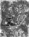
Well I haven't tried making a true city map yet, but I have made quantity of geographic and political maps of continents. Basicly I open paint, stretch the canvas to the desired size, use the bucket to pour in the blue for the oceans. Then using the pencil with black I draw the land outlines, as sketchy as possible for irregular cost lines. After that I have a small paint file I made with pre-made graphics for topography and geography (mountains, hills, forests, plains...). I use the same technique for rivers that I use for the coastlines. I've begun using the spray paint tool in an attempt to create a more gradual terrain change.
It's by no means the best. (Sorry for the quality but i switched to jpg since the original bitmap was far too large).
Attached File(s)
-
 New_j.JPG (140.56K)
Number of downloads: 4
This post has been edited by Darkwatch: 19 November 2008 - 06:20 AM
The Pub is Always Open
Proud supporter of the Wolves of Winter. Glory be to her Majesty, The Lady Snow.
Cursed Summer returns. The Lady Now Sleeps.
The Sexy Thatch Burning Physicist
Τον Πρωτος Αληθη Δεσποτην της Οικιας Αυτος
Proud supporter of the Wolves of Winter. Glory be to her Majesty, The Lady Snow.
Cursed Summer returns. The Lady Now Sleeps.
The Sexy Thatch Burning Physicist
Τον Πρωτος Αληθη Δεσποτην της Οικιας Αυτος
RodeoRanch said:
You're a rock.
A non-touching itself rock.
A non-touching itself rock.
#9
Yellow

- Sick and Tired
-

- Group: High House Mafia
- Posts: 1,703
- Joined: 22-February 05
Posted 22 November 2008 - 12:31 PM
I've tried campaign cartographer but I wasn't thrilled with it. Can't really remember why, except that it wasn't what I was looking for at the time. Maybe because it has random map generation? Can't remember if that's true or not.
Anyway, this website has a tutorial for creating maps using Photoshop (or similar). It's what I used to create some my maps (starting with pencil first).
http://www.brodt.dk/peter/maps.html
An example of mine using this... I'm sure you all could do better

Anyway, this website has a tutorial for creating maps using Photoshop (or similar). It's what I used to create some my maps (starting with pencil first).
http://www.brodt.dk/peter/maps.html
An example of mine using this... I'm sure you all could do better
Don't fuck with the Culture.
#10
Yellow
- Sick and Tired
-
- Group: High House Mafia
- Posts: 1,703
- Joined: 22-February 05
Posted 08 February 2009 - 09:08 AM
Has anyone come across any decent software for rendering a map as a globe? I mean taking the 2D image and mapping it to a sphere? I think this would be a really cool thing to have, to properly gauge distances and so on, but anything I've tried to do it in (mainly Bryce) has come out... cack-handed, to say the least.
I'd like to have something that did that for me automatically, as I have no skillz myself.
I'd like to have something that did that for me automatically, as I have no skillz myself.
This post has been edited by Yellow: 08 February 2009 - 09:09 AM
Don't fuck with the Culture.
#11
Sixty

- Don't be fooled. I am very serious.
-
- Group: High House Mafia
- Posts: 762
- Joined: 01-December 08
- Location:New Hampshire
Posted 08 February 2009 - 04:41 PM
I sketch the maps by hand then transport to photoshop and add everything in color there. My mountains suck but that can always be changed later. D:
#12
Soulessdreamer

- Fist
-
- Group: Malaz Regular
- Posts: 266
- Joined: 25-December 08
- Location:Hill of Bitter Memories, the City of Sails, in the Land of the Long White Cloud
- Interests:Sword fighting, HEMA, roleplaying, reading (fantasy and sci fi), weapons and Gaming (PC and Xbox)
Posted 11 February 2009 - 02:41 PM
As to mapping cities have you looked through historical archives? Old maps of cities can be reused with a little editing you could even combine bits you like from all over the world, at the very least it may give you some ideas.
TTFN
TTFN
Imagine a world without such souls.
Yes, it should have been harder to do.
Yes, it should have been harder to do.

#14
Yellow
- Sick and Tired
-
- Group: High House Mafia
- Posts: 1,703
- Joined: 22-February 05
Posted 28 February 2009 - 06:10 PM
Looks good  It has a neat, crisp finish to it... and the waves in the background work really well, I think.
I found a tutorial about how to go about mapping a 2D picture to a 3D sphere, and letting you interact with it, that's exactly what I was after. Except, the tutorial requires Flash, which I have no experience in, and is pitched way over my head.
http://www.insideria.com/2009/02/creating-...tive-globe.html
I tried putting this together myself (changing the jpg name etc), but all I got was a blank sheet. I think maybe I didn't put the plugins in the right place or something. Grrrrr.
But seriously, check out that globe in that link. It's great... and if anyone can convert this article into a complete Dummies-R-Us version (e.g. step-by-step guide from Flash installation onward), I would be eternally greatful
It has a neat, crisp finish to it... and the waves in the background work really well, I think.I found a tutorial about how to go about mapping a 2D picture to a 3D sphere, and letting you interact with it, that's exactly what I was after. Except, the tutorial requires Flash, which I have no experience in, and is pitched way over my head.
http://www.insideria.com/2009/02/creating-...tive-globe.html
I tried putting this together myself (changing the jpg name etc), but all I got was a blank sheet. I think maybe I didn't put the plugins in the right place or something. Grrrrr.
But seriously, check out that globe in that link. It's great... and if anyone can convert this article into a complete Dummies-R-Us version (e.g. step-by-step guide from Flash installation onward), I would be eternally greatful
Don't fuck with the Culture.
#15
Fist Gamet

- Mortal Sword
-
- Group: Malaz Regular
- Posts: 1,106
- Joined: 10-March 03
- Location:Wales...and London!
- Interests:Writing, reading, writing, climbing, writing, scuba diving and writing (not at the same time)
Posted 01 March 2009 - 12:06 AM
Nice map, Sixty, I like that. The instant I saw it it made me want to write about it - could see a dozen story ideas pop out from the geography alone. I tinkered around with some software myself a while back but I just didn't like any of them. I drew my maps by hand then scanned them. After that it was a simple task to edit, expand and change them around on good ol' paint. I'd post the world map up but it's quite large.
I know there are plenty of articles out there that will direct you in how to put a map together from scratch whilst keeping it realistic - ie, positions of mountains, rivers, forests, coasts, deserts, climates and so on.
I know there are plenty of articles out there that will direct you in how to put a map together from scratch whilst keeping it realistic - ie, positions of mountains, rivers, forests, coasts, deserts, climates and so on.
Victory is mine!
#16
Sixty
- Don't be fooled. I am very serious.
-
- Group: High House Mafia
- Posts: 762
- Joined: 01-December 08
- Location:New Hampshire
Posted 01 March 2009 - 05:58 AM
Thanks 
Yeah, I'm not sure everything about it is all that realistic...oh well. I liked how it turned out, took a while (especially tracing the coast w/ the pen tool). At least an hour or two.
Yeah, I'm not sure everything about it is all that realistic...oh well. I liked how it turned out, took a while (especially tracing the coast w/ the pen tool). At least an hour or two.
#17
Yellow
- Sick and Tired
-
- Group: High House Mafia
- Posts: 1,703
- Joined: 22-February 05
Posted 01 March 2009 - 10:37 AM
Worth it, though, I think. I find it a lot easier to write when there's a definite geography there on the paper, and yours looks very professional.
One problem I have is distances. I have no idea if the distances I'm writing about are actually realistic or not... my map up there is supposed to be a bit smaller than Earth, but when I read through all the things I've written about travelling times, etc, I think maybe my entire world is the size of Spain.
It's one of those things I don't give a damn about when I read books (I never look at maps or dramatis personaes), but I know that a lot of people take it seriously. I just can't be arsed going into that much detail with my mapping.
This post has been edited by Yellow: 01 March 2009 - 10:37 AM
Don't fuck with the Culture.
#18
Fist Gamet
- Mortal Sword
-
- Group: Malaz Regular
- Posts: 1,106
- Joined: 10-March 03
- Location:Wales...and London!
- Interests:Writing, reading, writing, climbing, writing, scuba diving and writing (not at the same time)
Posted 02 March 2009 - 09:27 PM
That's fair enough. I am one of those who does obsess a little over distances and actual passage of time in the story. It can be a pain working out if someone could actually make it to a certain place in time but, to be honest, it has proven to be a vital plot element and has driven parts of my story and taken it in directions I did not anticipate.
An easy way is to do this is to compare say, a country or continent in your world and then find something roughly comparable on earth (perhaps your empire is the size, roughly of the USA) then you get an instant feel for how far it is from one end to the other. Now, suppose it is like the USA with very little in the way of geographical barriers from east to west (one mountain range) then you could work out how long it would take A) a man walking On Horse C) Wagons D) Marching infantry and so on. Gets you in the ball park without too much effort.
Then with ships you can easily get the info on line about how far an old sailing ship could travel in a day or week. This way you don't need to be accuaret but it helps if it is believable.
An easy way is to do this is to compare say, a country or continent in your world and then find something roughly comparable on earth (perhaps your empire is the size, roughly of the USA) then you get an instant feel for how far it is from one end to the other. Now, suppose it is like the USA with very little in the way of geographical barriers from east to west (one mountain range) then you could work out how long it would take A) a man walking
On Horse C) Wagons D) Marching infantry and so on. Gets you in the ball park without too much effort.Then with ships you can easily get the info on line about how far an old sailing ship could travel in a day or week. This way you don't need to be accuaret but it helps if it is believable.
Victory is mine!
#19
Sixty
- Don't be fooled. I am very serious.
-
- Group: High House Mafia
- Posts: 762
- Joined: 01-December 08
- Location:New Hampshire
Posted 02 March 2009 - 10:39 PM
I used maths to figure mine out...
On mine, I assumed people traveled at 4mph for 8-10 hours a day (not sure the exact value) then decided I wanted them to go a certain distance in a certain number of days...
Then I based the rest of my scale on that.
For example, going by mine it's a little wider from coast to coast than the USA. This guy took 60 or so days to bike across the USA, so I'm guessing it's about the same for people on a wagon.
Meanwhile, my characters travel from Trent to Bavum in a little over 20 days....about a third of that, which is also about a third of the map.
Hey, the math actually worked out in hindsight.
This post has been edited by Sixty: 02 March 2009 - 10:43 PM
#20
Yellow
- Sick and Tired
-
- Group: High House Mafia
- Posts: 1,703
- Joined: 22-February 05
Posted 03 March 2009 - 07:23 AM
Yeah, all that is exactly the kind of stuff I can't be bothered doing What I tend to do is just be pretty vague. Things take "days" or "weeks" and elsewhere in the book, some non-specific amount of time has passed for other characters, though I try to give a general feeling of how long that time might have been. Plenty of wiggle room, baby 
I hate travelogues!
What I tend to do is just be pretty vague. Things take "days" or "weeks" and elsewhere in the book, some non-specific amount of time has passed for other characters, though I try to give a general feeling of how long that time might have been. Plenty of wiggle room, baby I hate travelogues!
Don't fuck with the Culture.


